1970s Maps of Starks, Maine
Explore 3 historic maps of Starks from the 1970s. These maps offer a rare glimpse into what life looked like during the 1970s — showing old roads, neighborhoods, homes, and landmarks that have changed or disappeared over time.
Whether you're researching your family's past, planning a metal detecting trip, or studying how Starks's landscape evolved across the 1970s, these high-resolution maps are a powerful tool for exploring the history of this region.
- Focus on a specific era: All maps on this page are from the 1970s, giving you a focused view of this time period.
- See what’s changed: Compare century-old streets, trails, and buildings to today's modern landscape using overlays and satellite layers.
- Research with precision: Use these maps for genealogy, historical research, land use analysis, or educational projects.
- View, download, or print: Maps are fully viewable online in high resolution, and can be downloaded or printed for your own records.
Start exploring Starks's history through authentic maps from the 1970s. This is your window into the past.
Starks, ME maps
(3)- 1975 Map of Norridgewock NW, 1980 Print
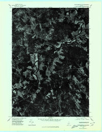 1975 Norridgewock NW1980 Print · USGSCentral Maine in the mid-seventies is revealed through this detailed orthophoto of the winding Sandy River valley. Genealogists and historians can trace the rural layouts of Starks and Mercer or locate homesteads along Bog Stream.
 - 1976 Map of Anson SW, 1980 Print
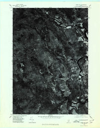 1976 Anson SW1980 Print · USGSSomerset County river settlements and timberlands are captured in this mid-seventies aerial study. Trace the industrial and residential footprints along the Kennebec River through Anson, North Anson, and Madison.
 - 1979 Map of New Vineyard, 1983 Print
 1979 New Vineyard1983 Print · USGSFranklin County's wooded hills and remote settlements are captured in this late 1970s aerial survey. Trace rural homesteads and land patterns around New Vineyard, West Mills, and the slopes of the New Vineyard Mountains.
End of results
Showing maps 1-3 of 3
Top cities near Starks
- Farmington historical maps
- Fairfield historical maps
- Skowhegan historical maps
- Oakland historical maps
- Madison historical maps
- Sidney historical maps
See more
Top neighborhoods of Starks
Frequently asked questions
- What are the different types of historical maps available for Starks?
- What is the oldest map of Starks?
- Where can I purchase historical maps of Starks for my home or office?
- Where can I download high-res historical maps of Starks?
- Are there historical topographic maps available for Starks?
- Is there historical aerial imagery available for Starks?
- Where are historical maps of Starks sourced from?