1990s Maps of Cutler, Maine
Explore 7 historic maps of Cutler from the 1990s. These maps offer a rare glimpse into what life looked like during the 1990s — showing old roads, neighborhoods, homes, and landmarks that have changed or disappeared over time.
Whether you're researching your family's past, planning a metal detecting trip, or studying how Cutler's landscape evolved across the 1990s, these high-resolution maps are a powerful tool for exploring the history of this region.
- Focus on a specific era: All maps on this page are from the 1990s, giving you a focused view of this time period.
- See what’s changed: Compare century-old streets, trails, and buildings to today's modern landscape using overlays and satellite layers.
- Research with precision: Use these maps for genealogy, historical research, land use analysis, or educational projects.
- View, download, or print: Maps are fully viewable online in high resolution, and can be downloaded or printed for your own records.
Start exploring Cutler's history through authentic maps from the 1990s. This is your window into the past.
Cutler, ME maps
(7)- 1993 Map of Machias Seal Island, 1995 Print
 1993 Machias Seal Island1995 Print · USGSCoastal Washington County and the maritime boundary waters are captured here in the early nineties. Maritime researchers can locate the Lighthouse on Machias Seal Island and identify the nearby North Rock amidst the Grand Manan Channel.
 - 1993 Map of Moose River, 1995 Print
 1993 Moose River1995 Print · USGSThe Washington County coastline in the early nineties reveals a landscape of tidal ledges and secluded coves where the Moose River meets the sea. Researchers can trace the shoreline of Cutler, from the depths of Norse Pond to the open waters of the Grand Manan Channel.
 - 1993 Map of Cutler, 1995 Print
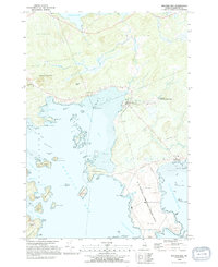
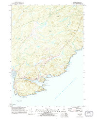 1993 Cutler1995 Print · USGSThe Washington County coastline in the early nineties reveals a landscape of protected harbors and rocky heads. Genealogists and maritime historians can locate the Old Cutler Cem, the Head of the River Ch, and the iconic Lighthouse on Little River Island.2 unique versions available
 - 1993 Map of Old Man, 1995 Print
 1993 Old Man1995 Print · USGSThe coastal waters of Washington County are captured here in the early nineties, centered on the strategic Grand Manan Channel. Maritime researchers can identify specific hazards like Flowers Rock and the island acreage of the Cross Island National Wildlife Refuge.
 - 1993 Map of Cross Island, 1995 Print
 1993 Cross Island1995 Print · USGSCoastal Washington County is captured here in the early nineties, centered on the protected lands of the Cross Island National Wildlife Refuge. Maritime researchers can locate the Lighthouse at Libby Islands and the US Naval Communication Unit near Thornton Point.
 - 1993 Map of Machias Bay, 1995 Print
 1993 Machias Bay1995 Print · USGSCoastal Washington County in the 1990s reveals a landscape shaped by military infrastructure and maritime conservation. Trace the restricted grounds of the U S Naval Communication Unit or explore the islands of the Cross Island National Wildlife Refuge and the harbor at North Cutler.2 unique versions available
 - 1994 Map of Machias
 1994 Machias1994 Print · USGSThe Downeast coast of Maine in the 1990s is captured here, from the Narraguagus River to the Canadian border. Genealogists and historians can trace coastal settlements like Jonesboro and Addison or locate the U.S. Naval Radio Station and Moosehorn National Wildlife Refuge.
End of results
Showing maps 1-7 of 7
Top cities near Cutler
- Machias historical maps
- East Machias historical maps
- Jonesport historical maps
- Lubec historical maps
- Machiasport historical maps
- Marshfield historical maps
See more
Top neighborhoods of Cutler
Frequently asked questions
- What are the different types of historical maps available for Cutler?
- What is the oldest map of Cutler?
- Where can I purchase historical maps of Cutler for my home or office?
- Where can I download high-res historical maps of Cutler?
- Are there historical topographic maps available for Cutler?
- Is there historical aerial imagery available for Cutler?
- Where are historical maps of Cutler sourced from?