1940s Maps of Cutler, Maine
Explore 8 historic maps of Cutler from the 1940s. These maps offer a rare glimpse into what life looked like during the 1940s — showing old roads, neighborhoods, homes, and landmarks that have changed or disappeared over time.
Whether you're researching your family's past, planning a metal detecting trip, or studying how Cutler's landscape evolved across the 1940s, these high-resolution maps are a powerful tool for exploring the history of this region.
- Focus on a specific era: All maps on this page are from the 1940s, giving you a focused view of this time period.
- See what’s changed: Compare century-old streets, trails, and buildings to today's modern landscape using overlays and satellite layers.
- Research with precision: Use these maps for genealogy, historical research, land use analysis, or educational projects.
- View, download, or print: Maps are fully viewable online in high resolution, and can be downloaded or printed for your own records.
Start exploring Cutler's history through authentic maps from the 1940s. This is your window into the past.
Cutler, ME maps
(8)- 1941 Map of Machias, 1956 Print
 1941 Machias1956 Print · USGSThe rugged Washington County coastline at the start of the 1940s reveals a world defined by the Maine Central railroad and tidal waters. Genealogists and historians can trace family-named landmarks such as Hoyttown, Dog Town, and the defensive site at Fort O'Brien Point.3 unique versions available
 - 1943 Map of Eastport, 1955 Print
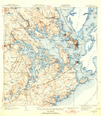 1943 Eastport1955 Print · USGSCoastal Washington County is defined here by its complex tidal bays and international border during the mid-forties. Genealogists and historians can trace the Maine Central Railroad through Dennysville Station or locate rural landmarks like the West Pembroke Ch and the Pleasant Point Indian Reservation.2 unique versions available
 - 1945 Map of Eastport
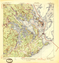 1945 Eastport1945 Print · USGSThe rugged coast of Washington County is captured here at the end of the war, showcasing the maritime hubs of Eastport and Lubec. Genealogists can trace family names across Ayers Junction, locate rural landmarks like the Wilcox Sch, and explore the early bounds of the Moosehorn National Wildlife Refuge.2 unique versions available
 - 1949 Map of Whiting, 1952 Print
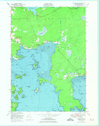
 1949 Whiting1952 Print · USGSCoastal Washington County is seen here just after the war, showcasing a landscape defined by the tidal reaches of Whiting Bay and the Orange River. Researchers can locate old community landmarks like the East Stream Sch, the Lookout Tower on Littles Mtn, and maritime Pier Ruins.3 unique versions available
 - 1949 Map of Moose River, 1967 Print
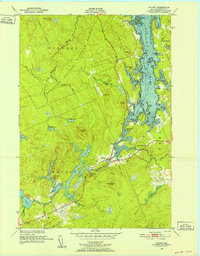
 1949 Moose River1967 Print · USGSThe Washington County coastline and the Grand Manan Channel are captured here just after the war. Researchers can trace local maritime landmarks like Eastern Head and the site of the Moose River School.
 - 1949 Map of Cutler, 1968 Print
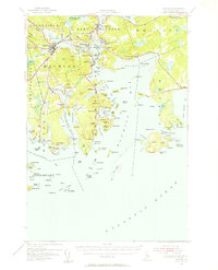
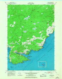 1949 Cutler1968 Print · USGSCoastal Washington County is shown here just after the war, detailing the maritime and rural life of the Downeast shore. Genealogists and historians can trace family-named landmarks like Dennison and Huntley alongside the Little River Lighthouse and Bay View Cem.2 unique versions available
 - 1949 Map of Cross Island, 1969 Print
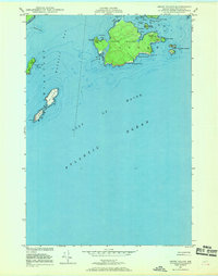 1949 Cross Island1969 Print · USGSThe Washington County coastline at the end of the 1940s reveals a maritime landscape shaped by navigation and defense. Genealogists and historians can locate the Cross Island Coast Guard Sta and the Lighthouse on the Libby Islands amidst the waters of Machias Bay.2 unique versions available
 - 1949 Map of Machias Bay, 1974 Print
 1949 Machias Bay1974 Print · USGSCoastal Washington County is captured here in the late 1940s, showing the intricate maritime landscape from Machias Bay to Cutler. Genealogists and historians can locate old landmarks like Holmes Bay Ch, Holmes Bay Sch, and the small settlement at Holway.2 unique versions available
End of results
Showing maps 1-8 of 8
Top cities near Cutler
- Machias historical maps
- East Machias historical maps
- Jonesport historical maps
- Lubec historical maps
- Machiasport historical maps
- Marshfield historical maps
See more
Top neighborhoods of Cutler
Frequently asked questions
- What are the different types of historical maps available for Cutler?
- What is the oldest map of Cutler?
- Where can I purchase historical maps of Cutler for my home or office?
- Where can I download high-res historical maps of Cutler?
- Are there historical topographic maps available for Cutler?
- Is there historical aerial imagery available for Cutler?
- Where are historical maps of Cutler sourced from?