1940s Maps of North Cutler, Cutler
Explore 2 historic maps of North Cutler from the 1940s. These maps offer a rare glimpse into what life looked like during the 1940s — showing old roads, neighborhoods, homes, and landmarks that have changed or disappeared over time.
Whether you're researching your family's past, planning a metal detecting trip, or studying how North Cutler's landscape evolved across the 1940s, these high-resolution maps are a powerful tool for exploring the history of this region.
- Focus on a specific era: All maps on this page are from the 1940s, giving you a focused view of this time period.
- See what’s changed: Compare century-old streets, trails, and buildings to today's modern landscape using overlays and satellite layers.
- Research with precision: Use these maps for genealogy, historical research, land use analysis, or educational projects.
- View, download, or print: Maps are fully viewable online in high resolution, and can be downloaded or printed for your own records.
Start exploring North Cutler's history through authentic maps from the 1940s. This is your window into the past.
North Cutler, Cutler maps
(2)- 1941 Map of Machias, 1956 Print
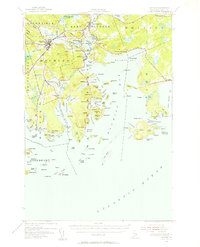 1941 Machias1956 Print · USGSThe rugged Washington County coastline at the start of the 1940s reveals a world defined by the Maine Central railroad and tidal waters. Genealogists and historians can trace family-named landmarks such as Hoyttown, Dog Town, and the defensive site at Fort O'Brien Point.3 unique versions available
 - 1949 Map of Machias Bay, 1974 Print
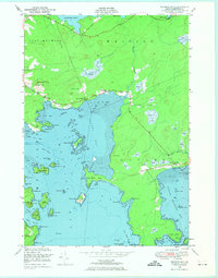 1949 Machias Bay1974 Print · USGSCoastal Washington County is captured here in the late 1940s, showing the intricate maritime landscape from Machias Bay to Cutler. Genealogists and historians can locate old landmarks like Holmes Bay Ch, Holmes Bay Sch, and the small settlement at Holway.2 unique versions available
End of results
Showing maps 1-2 of 2
Frequently asked questions
- What are the different types of historical maps available for North Cutler?
- What is the oldest map of North Cutler?
- Where can I purchase historical maps of North Cutler for my home or office?
- Where can I download high-res historical maps of North Cutler?
- Are there historical topographic maps available for North Cutler?
- Is there historical aerial imagery available for North Cutler?
- Where are historical maps of North Cutler sourced from?