1950s Maps of Jonesboro, Maine
Explore 6 historic maps of Jonesboro from the 1950s. These maps offer a rare glimpse into what life looked like during the 1950s — showing old roads, neighborhoods, homes, and landmarks that have changed or disappeared over time.
Whether you're researching your family's past, planning a metal detecting trip, or studying how Jonesboro's landscape evolved across the 1950s, these high-resolution maps are a powerful tool for exploring the history of this region.
- Focus on a specific era: All maps on this page are from the 1950s, giving you a focused view of this time period.
- See what’s changed: Compare century-old streets, trails, and buildings to today's modern landscape using overlays and satellite layers.
- Research with precision: Use these maps for genealogy, historical research, land use analysis, or educational projects.
- View, download, or print: Maps are fully viewable online in high resolution, and can be downloaded or printed for your own records.
Start exploring Jonesboro's history through authentic maps from the 1950s. This is your window into the past.
Jonesboro, ME maps
(6)- 1951 Map of Machias
 1951 Machias1951 Print · USGSCoastal Washington County is captured here in the early fifties, showing the vital rail-and-sea connections of Machias. Genealogists and historians can trace family locations in Dog Town, locate the Longfellow Cem, or explore the grounds of Fort O'Brien Pt.
 - 1951 Map of Addison
 1951 Addison1951 Print · USGSCoastal Washington County is depicted here in the early fifties, showing the intricate tidal network of the Downeast shore. Researchers can trace the layout of waterfront communities like South Addison and locate vanished landmarks such as the Upper East Side School.
 - 1951 Map of Columbia Falls
 1951 Columbia Falls1951 Print · USGSCoastal Washington County during the mid-century period shows a landscape defined by timber, rail, and the tides. Genealogists and historians can trace family locations near Columbia Falls, Jonesboro Station, and the heights of Milton Mtn.
 - 1951 Map of Whitneyville
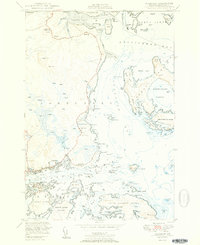
 1951 Whitneyville1951 Print · USGSThe coastal inlets and timberlands of Washington County come alive in this mid-century survey of Jonesboro and Whitneyville. Researchers can trace the path of the Maine Central railroad and locate old landmarks like the White School or Mt Misery.
 - 1951 Map of Jonesport
 1951 Jonesport1951 Print · USGSCoastal Washington County at mid-century reveals a landscape of seafaring villages and intricate tidal waterways. Researchers can trace genealogical roots through landmarks like the Kelley School, Greenwood Cem, and the settlement of Monsonpec.2 unique versions available
 - 1953 Map of Columbia Falls
 1953 Columbia Falls1953 Print · USGSCoastal Washington County is captured here in the early fifties, showing the rail-and-river economy of the Downeast region. Genealogists can locate the Central District and Columbia Falls settlement, while tracing the old Maine Central rail line.
End of results
Showing maps 1-6 of 6
Top cities near Jonesboro
- Machias historical maps
- Milbridge historical maps
- East Machias historical maps
- Jonesport historical maps
- Addison historical maps
- Harrington historical maps
See more
Frequently asked questions
- What are the different types of historical maps available for Jonesboro?
- What is the oldest map of Jonesboro?
- Where can I purchase historical maps of Jonesboro for my home or office?
- Where can I download high-res historical maps of Jonesboro?
- Are there historical topographic maps available for Jonesboro?
- Is there historical aerial imagery available for Jonesboro?
- Where are historical maps of Jonesboro sourced from?