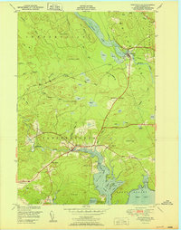
1951 Map of Whitneyville
USGS Topo · Published 1951About this map
Whitneyville and Jonesboro anchor this coastal Washington County landscape, where the tidal reaches of the Chandler River meet the Atlantic at Roque Bluffs. The map illustrates a mid-century Downeast economy still deeply connected to its waterways and the Maine Central railroad, which cuts across the terrain from Centerville through the heart of Whitneyville. Numerous marshes and peatlands, simply labeled as Heath, dominate the low-lying areas between rocky rises like Kilton Mtn and the aptly named Mt Misery.
Find a feature on this map
44 named features on this map. Tap any name to fly to it.
Don’t see what you’re looking for? This feature index may not catch every label — zoom into the map to look around manually.
Map Details
Editions of this 1951 Whitneyville Map
This is the sole edition of this map. No revisions or reprints were ever made.
Other maps of this area

1918 · Machias
USGS Topo · 1:62,500

1921 · Columbia Falls
USGS Topo · 1:62,500

1921 · Columbia Falls
USGS Topo · 1:62,500

1941 · Columbia Falls
USGS Topo · 1:62,500

1941 · Machias
USGS Topo · 1:62,500

1941 · Wesley
USGS Topo · 1:62,500

1941 · Gardner Lake
USGS Topo · 1:62,500

1942 · Columbia Falls
USGS Topo · 1:62,500

1943 · Wesley
USGS Topo · 1:62,500

1943 · Gardner Lake
USGS Topo · 1:62,500