Old Maps of Elsemore Landing, T6 ND BPP for Metal Detecting
Plan your next treasure hunt with 15 historic maps of Elsemore Landing. Find old homesites, ghost towns, trails, and gathering spots that may be lost to time — perfect for identifying promising metal detecting locations.
- Locate forgotten sites: Uncover places like long-lost settlements, abandoned rail lines, or gathering spots.
- Plan better hunts: Use map overlays combined with LiDAR or satellite views to narrow in on historically rich areas.
- Made for detectorists: Thousands of hobbyists use these maps to discover relics, coins, and hidden history.
Use these historic maps to boost your research and find new opportunities beneath the surface of Elsemore Landing.
Elsemore Landing, T6 ND BPP maps
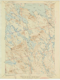
(15)- 1941 Map of Wabassus Lake, 1962 Print
 1941 Wabassus Lake1962 Print · USGSThe Downeast timberlands of Washington County were a labyrinth of logging camps and glacial lakes just before the mid-century. Researchers can trace the water-and-woods economy through Farm Cove Dam, the Dennison Portage, and the village of Grand Lake Stream.
 - 1943 Map of Wabassus Lake
 1943 Wabassus Lake1943 Print · USGSThe Maine wilderness of Washington County comes alive in the 1940s through its intricate network of lakes, logging camps, and traditional portages. Local historians can trace the foundations of Grand Lake Stream or locate remote sites like The Birches and Holland Camp.3 unique versions available
 - 1953 Map of Wabassus Lake, 1984 Print
 1953 Wabassus Lake1984 Print · USGSMaine's wilderness townships come to life in this mid-century survey of the interconnected waterways north of the Machias River. Researchers can trace historic forest service landmarks like the State Forest Service Camp or locate the village of Grand Lake Stream and its local cemetery.
 - 1957 Map of Fredericton, 1981 Print
 1957 Fredericton1981 Print · USGSThe New Brunswick and Maine borderlands come into focus in the mid-fifties, dominated by the Saint John River and massive military tracts. Genealogists can locate riverfront hamlets like Maugerville or inland sites like Scotch Settlement along the Canadian Pacific rail line.
 - 1963 Map of Fredericton
 1963 Fredericton1963 Print · USGSThe Saint John River valley and the Maine-New Brunswick border are captured here during the early sixties. Researchers can trace the Canadian Pacific rail lines through rural settlements like Jewetts Mills, Mckeens Corner, and Scotch Settlement.
 - 1963 Map of Wabassus Lake, 1966 Print
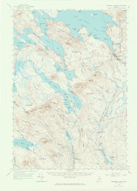 1963 Wabassus Lake1966 Print · USGSThe interconnected lakes and forest camps of eastern Maine are captured here in the mid-1960s. Researchers can trace historical portages and remote outposts like Elsemore Landing, the State Forest Service Camp, and Grand Lake Stream.2 unique versions available
 - 1975 Map of Wabassus Lake NW, 1980 Print
 1975 Wabassus Lake NW1980 Print · USGSThe Maine North Woods and the jagged eastern shores of West Grand Lake are captured here in the mid-seventies. Researchers can trace forest management patterns and lake topography near the heights of Dark Cove Mountain.
 - 1986 Map of Calais
 1986 Calais1986 Print · USGSCoastal and interior Washington County are captured here in the mid-1980s, where the international border follows the winding St Croix River. Genealogists and historians can trace the rail lines of the Maine Central and find landmarks like Red Beach and Princeton Airport.
 - 1990 Map of Dark Cove Mountain
 1990 Dark Cove Mountain1990 Print · USGSThe interconnected lakes of Washington County are shown in great detail during the late twentieth century, before the digital age reshaped backcountry navigation. Trace historical water routes and portages including Dennison Portage, Dobsis Dam, and the landing at Elsemore Landing.
 - 1994 Map of Calais
 1994 Calais1994 Print · USGSEastern Maine's river and lake country comes into focus in the 1990s, centered on the international border at Calais and the vast Passamaquoddy Indian Reservation. Researchers can trace the water-linked settlements of Grand Lake Stream, the airfield at Princeton Airport, and the industrial heritage of Woodland.
 - 2011 Map of Dark Cove Mountain, 2011 Print
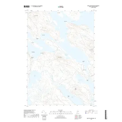
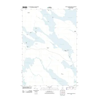 2011 Dark Cove Mountain2011 Print · USGSCovers Elsemore Landing, including T42 MD BPP, Sakom Township, and other nearby areas
 - 2014 Map of Dark Cove Mountain, 2014 Print
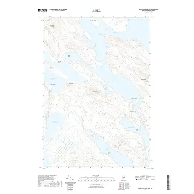
 2014 Dark Cove Mountain2014 Print · USGSCovers Elsemore Landing, including T42 MD BPP, Sakom Township, and other nearby areas
 - 2018 Map of Dark Cove Mountain, 2018 Print
 2018 Dark Cove Mountain2018 Print · USGSCovers Elsemore Landing, including T42 MD BPP, Sakom Township, and other nearby areas
 - 2021 Map of Dark Cove Mountain, 2021 Print
 2021 Dark Cove Mountain2021 Print · USGSCovers Elsemore Landing, including T42 MD BPP, Sakom Township, and other nearby areas
 - 2024 Map of Dark Cove Mountain, 2024 Print
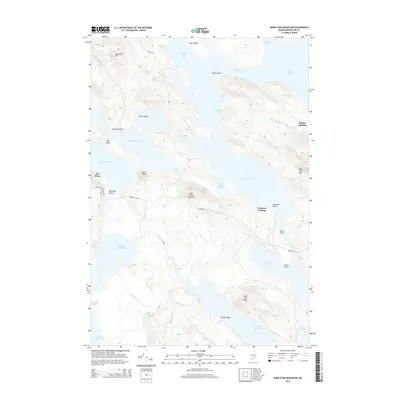
 2024 Dark Cove Mountain2024 Print · USGSWashington County’s labyrinth of interconnected lakes and glacial ridges is documented here in the modern era. Follow the intricate shorelines from The Pines to Dark Cove Mtn, or trace the waterways through Pocumcus Narrows and Fourth Lake Stream.
End of results
Showing maps 1-15 of 15
Top cities near Elsemore Landing
- Springfield historical maps
- Topsfield historical maps
- Carroll Plantation historical maps
- Grand Lake Stream historical maps
- Wesley historical maps
- Lakeville historical maps
See more
Frequently asked questions
- What are the different types of historical maps available for Elsemore Landing?
- What is the oldest map of Elsemore Landing?
- Where can I purchase historical maps of Elsemore Landing for my home or office?
- Where can I download high-res historical maps of Elsemore Landing?
- Are there historical topographic maps available for Elsemore Landing?
- Is there historical aerial imagery available for Elsemore Landing?
- Where are historical maps of Elsemore Landing sourced from?