1910s Maps of Whiting, Maine
Explore 3 historic maps of Whiting from the 1910s. These maps offer a rare glimpse into what life looked like during the 1910s — showing old roads, neighborhoods, homes, and landmarks that have changed or disappeared over time.
Whether you're researching your family's past, planning a metal detecting trip, or studying how Whiting's landscape evolved across the 1910s, these high-resolution maps are a powerful tool for exploring the history of this region.
- Focus on a specific era: All maps on this page are from the 1910s, giving you a focused view of this time period.
- See what’s changed: Compare century-old streets, trails, and buildings to today's modern landscape using overlays and satellite layers.
- Research with precision: Use these maps for genealogy, historical research, land use analysis, or educational projects.
- View, download, or print: Maps are fully viewable online in high resolution, and can be downloaded or printed for your own records.
Start exploring Whiting's history through authentic maps from the 1910s. This is your window into the past.
Whiting, ME maps
(3)- 1917 Map of Cutler, 1965 Print
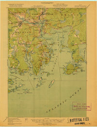
 1917 Cutler1965 Print · USGSCoastal Washington County is shown here during the late First World War era as a landscape of isolated fishing villages and rocky peninsulas. Genealogists and researchers can trace local landmarks like Moose River School, the village of Cutler, and family-named spots such as Harmon Heath.
 - 1918 Map of Machias
 1918 Machias1918 Print · USGSThe Downeast coast of Washington County comes alive in the years during the Great War, showing the maritime and rail infrastructure that drove the regional economy. Genealogists and historians can trace family-named landmarks and old coastal outposts like Dog Town, Fort O'Brien Point, and the Cross Island L S S.5 unique versions available
 - 1918 Map of Cutler
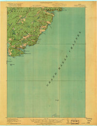 1918 Cutler1918 Print · USGSThe Downeast coast of Washington County is captured here just after the Great War, showing a landscape defined by maritime industry and remote schools. Genealogists can trace early homesteads and community sites like School No 2, Moose River School, and the rocky outposts of Machias Seal I.5 unique versions available
End of results
Showing maps 1-3 of 3
Top cities near Whiting
- Machias historical maps
- East Machias historical maps
- Eastport historical maps
- Jonesport historical maps
- Lubec historical maps
- Machiasport historical maps
See more
Top neighborhoods of Whiting
Frequently asked questions
- What are the different types of historical maps available for Whiting?
- What is the oldest map of Whiting?
- Where can I purchase historical maps of Whiting for my home or office?
- Where can I download high-res historical maps of Whiting?
- Are there historical topographic maps available for Whiting?
- Is there historical aerial imagery available for Whiting?
- Where are historical maps of Whiting sourced from?