1970s Maps of York County, Maine
Explore 14 historic maps of York County from the 1970s. These maps offer a rare glimpse into what life looked like during the 1970s — showing old roads, neighborhoods, homes, and landmarks that have changed or disappeared over time.
Whether you're researching your family's past, planning a metal detecting trip, or studying how York County's landscape evolved across the 1970s, these high-resolution maps are a powerful tool for exploring the history of this region.
- Focus on a specific era: All maps on this page are from the 1970s, giving you a focused view of this time period.
- See what’s changed: Compare century-old streets, trails, and buildings to today's modern landscape using overlays and satellite layers.
- Research with precision: Use these maps for genealogy, historical research, land use analysis, or educational projects.
- View, download, or print: Maps are fully viewable online in high resolution, and can be downloaded or printed for your own records.
Start exploring York County's history through authentic maps from the 1970s. This is your window into the past.
York County, ME maps
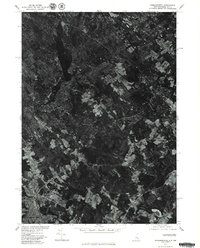
(14)- 1975 Map of Prouts Neck, 1979 Print
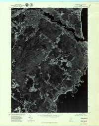
 1975 Prouts Neck1979 Print · USGSCoastal Cumberland County is shown in the mid-seventies, featuring the winding tidal marshes of the Nonesuch River. Researchers can trace the development of beach communities at Prouts Neck, Higgins Beach, and the historic grid of Old Orchard Beach.
 - 1975 Map of Biddeford, 1979 Print
 1975 Biddeford1979 Print · USGSCoastal Maine in the mid-seventies is revealed through this aerial orthophotoquad of the shoreline and its interior settlements. Genealogists and historians can trace the 1975 footprints of Biddeford, Guinea Road Corner, and the rocky inlets of Fortunes Rocks.
 - 1975 Map of Kennebunkport, 1979 Print
 1975 Kennebunkport1979 Print · USGSThe Maine coast in the mid-seventies is captured here via detailed aerial photography, showing the transition of these maritime villages. Researchers can trace the layout of waterfronts and neighborhoods near Kennebunkport, Cape Porpoise, and Coopers Corner.
 - 1975 Map of Gorham, 1979 Print
 1975 Gorham1979 Print · USGSCumberland County communities are seen in transition during the mid-seventies as suburban patterns emerge among older farmsteads. Researchers can trace land use near Gorham and Westbrook or follow the courses of the Presumpscot River and Nonesuch River.
 - 1975 Map of Old Orchard Beach, 1979 Print
 1975 Old Orchard Beach1979 Print · USGSCoastal Maine settlement meets the Atlantic in the mid-seventies, captured in high-detail aerial photography. Trace the growth of Old Orchard Beach and West Scarborough along the banks of the Nonesuch River.
 - 1975 Map of Cornish, 1979 Print
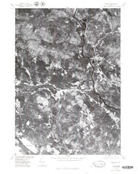 1975 Cornish1979 Print · USGSMaine's river-valley communities are captured in this mid-seventies aerial survey of York County. Researchers can trace land use patterns near Cornish and the winding banks of the Saco River and Ossipee River.
 - 1975 Map of Biddeford Pool, 1979 Print
 1975 Biddeford Pool1979 Print · USGSCoastal Maine in the mid-seventies is captured in this detailed aerial orthophotograph of the York County shoreline. Genealogists and historians can examine the exact layout of Biddeford Pool and the natural features of The Pool and Fortunes Rocks.
 - 1977 Map of Wells, 1979 Print
 1977 Wells1979 Print · USGSCoastal Maine in the late seventies is revealed through this detailed aerial survey of the York County shoreline. Genealogists and historians can trace the precise layout of Wells, Ogunquit, and the tidal waters of the Webhannet River.
 - 1977 Map of York Beach, 1979 Print
 1977 York Beach1979 Print · USGSCoastal Maine at the end of the seventies is captured in this detailed aerial study of the shoreline. Genealogists and local historians can trace property footprints and the layout of seaside communities in Ogunquit and York Beach.
 - 1977 Map of Dover East, 1979 Print
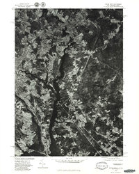 1977 Dover East1979 Print · USGSThe borderlands of New Hampshire and Maine are seen here in the late seventies as the industrial river towns continued their evolution. Researchers can trace the winding Salmon Falls River and the historical footprints of Somersworth and Dover.
 - 1977 Map of York Harbor, 1979 Print
 1977 York Harbor1979 Print · USGSCoastal Maine in the late seventies is captured in this orthophoto survey of the York coastline and its forested interior. Researchers can trace the winding York River and identify historical settlement patterns at Scotland, Beech Ridge, and Brixham Lower Corners.
 - 1977 Map of Somersworth, 1979 Print
 1977 Somersworth1979 Print · USGSThe industrial centers of Somersworth and Berwick appear as they were in the late seventies in this aerial survey. You can trace the actual riverfront development and rural landmarks like the Beaver Dam across the Maine-New Hampshire border.
 - 1977 Map of North Berwick, 1979 Print
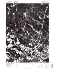
 1977 North Berwick1979 Print · USGSCoastal Maine's interior woodlands and agricultural clearings are captured in this aerial survey from the late seventies. Family-named junctions and rural landmarks are easy to trace, including Parsonage Corner, Grays Corner, and the industrial site at Works.
 - 1977 Map of Kittery, 1981 Print
 1977 Kittery1981 Print · USGSThe Maine and New Hampshire coastline comes into sharp focus during the late seventies, revealing the maritime landscape of the Piscataqua River area. Researchers can trace development on Seavey Island and the layouts of Kittery Point and Fairhill Manor.
End of results
Showing maps 1-14 of 14
Top cities of York County
- Biddeford historical maps
- Sanford historical maps
- Saco historical maps
- York historical maps
- Kennebunk historical maps
- Wells historical maps
See more
Frequently asked questions
- What are the different types of historical maps available for York County?
- What is the oldest map of York County?
- Where can I purchase historical maps of York County for my home or office?
- Where can I download high-res historical maps of York County?
- Are there historical topographic maps available for York County?
- Is there historical aerial imagery available for York County?
- Where are historical maps of York County sourced from?