1940s Maps of Kittery, Maine
Explore 6 historic maps of Kittery from the 1940s. These maps offer a rare glimpse into what life looked like during the 1940s — showing old roads, neighborhoods, homes, and landmarks that have changed or disappeared over time.
Whether you're researching your family's past, planning a metal detecting trip, or studying how Kittery's landscape evolved across the 1940s, these high-resolution maps are a powerful tool for exploring the history of this region.
- Focus on a specific era: All maps on this page are from the 1940s, giving you a focused view of this time period.
- See what’s changed: Compare century-old streets, trails, and buildings to today's modern landscape using overlays and satellite layers.
- Research with precision: Use these maps for genealogy, historical research, land use analysis, or educational projects.
- View, download, or print: Maps are fully viewable online in high resolution, and can be downloaded or printed for your own records.
Start exploring Kittery's history through authentic maps from the 1940s. This is your window into the past.
Kittery, ME maps
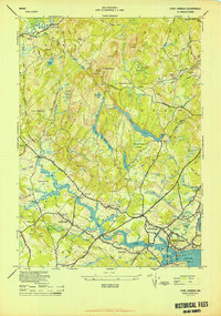
(6)- 1941 Map of Dover
 1941 Dover1941 Print · USGSCoastal New Hampshire and the Maine borderlands are captured here just before the mobilization of the early 1940s. Genealogists can trace family lands near Garrison Hill, old district schools like Witchtrot Sch, and the rail depots at Greenland Village Sta.
 - 1943 Map of Cape Ann
 1943 Cape Ann1943 Print · USGSCoastal Massachusetts and New Hampshire appear here during the wartime era, showing the maritime and rail infrastructure that defined the North Shore. Genealogists can trace family names across Asbury Grove, Merrimacport, and the Boston & Maine RR rail corridor.
 - 1944 Map of Kittery
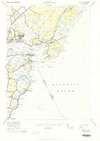 1944 Kittery1944 Print · USGSThe Maine and New Hampshire coastlines are shown here at the height of World War II, revealing a landscape defined by strategic defense. Genealogists and historians can trace family land and military footprints at Fort Dearborn, Admiralty Village, and Kittery Point.2 unique versions available
 - 1944 Map of York Harbor
 1944 York Harbor1944 Print · USGSCoastal Maine in the 1940s reveals a landscape of tidal rivers and forested hills where colonial history meets modern settlement. Genealogists can locate family-named sites like McIntire Garrison, Barrell Farm, and landmarks such as the Agamenticus Fire Tower.2 unique versions available
 - 1948 Map of Boston
 1948 Boston1948 Print · USGSEastern Massachusetts and southern New Hampshire appear at an industrial peak in the late 1940s, just as suburban growth began to accelerate. Genealogists and historians can trace rail lines like the Boston and Albany RR or locate coastal landmarks like Graves Lighthouse and Fort Devens.2 unique versions available
 - 1949 Map of Portland
 1949 Portland1949 Print · USGSCoastal Maine and the New Hampshire interior are shown in detail during the late forties, from the bustling harbors to the lakeside villages. Researchers can trace historical rail networks like the Boston & Maine RR and locate coastal defenses such as Fort Preble.3 unique versions available
End of results
Showing maps 1-6 of 6
Top cities near Kittery
- Dover historical maps
- Portsmouth historical maps
- Newburyport historical maps
- Hampton historical maps
- York historical maps
- Somersworth historical maps
See more
Top neighborhoods of Kittery
- Remick Corners historical maps
- Bedell Crossing historical maps
- Shepherds Hill historical maps
- Admiralty Village historical maps
- Oak Terrace historical maps
- Kittery Foreside historical maps
See more
Frequently asked questions
- What are the different types of historical maps available for Kittery?
- What is the oldest map of Kittery?
- Where can I purchase historical maps of Kittery for my home or office?
- Where can I download high-res historical maps of Kittery?
- Are there historical topographic maps available for Kittery?
- Is there historical aerial imagery available for Kittery?
- Where are historical maps of Kittery sourced from?