1970s Maps of Kittery, Maine
Explore 3 historic maps of Kittery from the 1970s. These maps offer a rare glimpse into what life looked like during the 1970s — showing old roads, neighborhoods, homes, and landmarks that have changed or disappeared over time.
Whether you're researching your family's past, planning a metal detecting trip, or studying how Kittery's landscape evolved across the 1970s, these high-resolution maps are a powerful tool for exploring the history of this region.
- Focus on a specific era: All maps on this page are from the 1970s, giving you a focused view of this time period.
- See what’s changed: Compare century-old streets, trails, and buildings to today's modern landscape using overlays and satellite layers.
- Research with precision: Use these maps for genealogy, historical research, land use analysis, or educational projects.
- View, download, or print: Maps are fully viewable online in high resolution, and can be downloaded or printed for your own records.
Start exploring Kittery's history through authentic maps from the 1970s. This is your window into the past.
Kittery, ME maps
(3)- 1977 Map of Dover East, 1979 Print
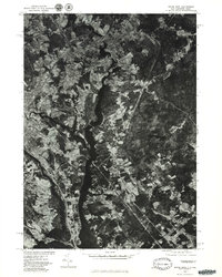 1977 Dover East1979 Print · USGSThe borderlands of New Hampshire and Maine are seen here in the late seventies as the industrial river towns continued their evolution. Researchers can trace the winding Salmon Falls River and the historical footprints of Somersworth and Dover.
 - 1977 Map of York Harbor, 1979 Print
 1977 York Harbor1979 Print · USGSCoastal Maine in the late seventies is captured in this orthophoto survey of the York coastline and its forested interior. Researchers can trace the winding York River and identify historical settlement patterns at Scotland, Beech Ridge, and Brixham Lower Corners.
 - 1977 Map of Kittery, 1981 Print
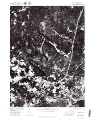
 1977 Kittery1981 Print · USGSThe Maine and New Hampshire coastline comes into sharp focus during the late seventies, revealing the maritime landscape of the Piscataqua River area. Researchers can trace development on Seavey Island and the layouts of Kittery Point and Fairhill Manor.
End of results
Showing maps 1-3 of 3
Top cities near Kittery
- Dover historical maps
- Portsmouth historical maps
- Newburyport historical maps
- Hampton historical maps
- York historical maps
- Somersworth historical maps
See more
Top neighborhoods of Kittery
- Remick Corners historical maps
- Bedell Crossing historical maps
- Shepherds Hill historical maps
- Admiralty Village historical maps
- Oak Terrace historical maps
- Kittery Foreside historical maps
See more
Frequently asked questions
- What are the different types of historical maps available for Kittery?
- What is the oldest map of Kittery?
- Where can I purchase historical maps of Kittery for my home or office?
- Where can I download high-res historical maps of Kittery?
- Are there historical topographic maps available for Kittery?
- Is there historical aerial imagery available for Kittery?
- Where are historical maps of Kittery sourced from?