1940s Maps of Towson, Maryland
Explore 8 historic maps of Towson from the 1940s. These maps offer a rare glimpse into what life looked like during the 1940s — showing old roads, neighborhoods, homes, and landmarks that have changed or disappeared over time.
Whether you're researching your family's past, planning a metal detecting trip, or studying how Towson's landscape evolved across the 1940s, these high-resolution maps are a powerful tool for exploring the history of this region.
- Focus on a specific era: All maps on this page are from the 1940s, giving you a focused view of this time period.
- See what’s changed: Compare century-old streets, trails, and buildings to today's modern landscape using overlays and satellite layers.
- Research with precision: Use these maps for genealogy, historical research, land use analysis, or educational projects.
- View, download, or print: Maps are fully viewable online in high resolution, and can be downloaded or printed for your own records.
Start exploring Towson's history through authentic maps from the 1940s. This is your window into the past.
Towson, MD maps
(8)- 1943 Map of Cockeysville, 1958 Print
 1943 Cockeysville1958 Print · USGSBaltimore County in the early forties shows a landscape of grand estates and burgeoning suburbs along the PENNSYLVANIA railroad. Researchers can locate vanished landmarks like the Eccleston P O or trace early footprints at Druid Ridge Cemetery and Saters Church.
 - 1943 Map of Baltimore, 1963 Print
 1943 Baltimore1963 Print · USGSMaryland's principal port city and the rolling hills of Baltimore County are shown here during the Second World War. Researchers can trace the heritage of the harbor and northern suburbs, identifying landmarks like Fort McHenry National Mon, Loudon Park National Cem, and the old Ashland Furnace.3 unique versions available
 - 1944 Map of Baltimore West
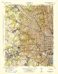 1944 Baltimore West1944 Print · USGSWestern Baltimore and its suburban fringes are frozen in time during the mid-1940s, showing a landscape of institutional campuses and growing streetcar suburbs. Genealogists and historians can locate family sites near Loudon Park Cemetery, St Agnes Hospital, and Pimlico Race Track.
 - 1944 Map of Towson
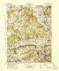
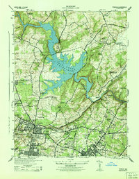 1944 Towson1944 Print · USGSMid-century Baltimore County shows a landscape of growing academic campuses and quiet reservoir shores just north of the city limits. Researchers can trace the footprints of Goucher College, the Loch Raven Dam, and local landmarks like Cromwell Bridge.2 unique versions available
 - 1944 Map of Cockeysville
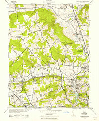
 1944 Cockeysville1944 Print · USGSThe northern Baltimore County suburbs were in a period of transition during the mid-forties as rail lines connected established towns with new recreational estates. Genealogists and historians can trace family plots at Druid Ridge Cemetery or locate wartime military activity at the Maryland State Fair Grounds.
 - 1944 Map of Baltimore
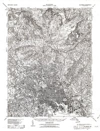
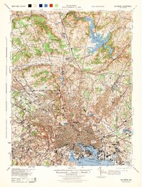 1944 Baltimore1944 Print · USGSMid-century Baltimore and its northern suburbs are shown in exceptional detail at the height of the war years. Local historians can trace the early footprints of Johns Hopkins University, the defenses at Fort McHenry, and the rural character of Green Spring Valley before modern development.
 - 1944 Map of Baltimore East
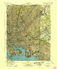 1944 Baltimore East1944 Print · USGSThe industrial heart of Baltimore pulses during the war years, from the busy docks of the Northwest Branch to the military grounds at Camp Holabird. Genealogists and historians can trace neighborhood growth in Highlandtown or locate historic institutions like Taylors Chapel and Notre Dame College.
 - 1948 Map of Baltimore
 1948 Baltimore1948 Print · USGSMaryland and Pennsylvania crossroads are captured in the late 1940s, showing a landscape defined by historic rail lines and major military installations. Genealogists can trace family connections in Gettysburg, Westminster, and near the U.S. Naval Academy in Annapolis.2 unique versions available
End of results
Showing maps 1-8 of 8
Top cities near Towson
- Baltimore historical maps
- Dundalk historical maps
- Towson historical maps
- Ellicott City historical maps
- Catonsville historical maps
- Woodlawn historical maps
See more
Top neighborhoods of Towson
- Riderwood historical maps
- East Towson historical maps
- Towson Estates historical maps
- Ruxton historical maps
- Towson historical maps
- Pinehurst historical maps
See more
Frequently asked questions
- What are the different types of historical maps available for Towson?
- What is the oldest map of Towson?
- Where can I purchase historical maps of Towson for my home or office?
- Where can I download high-res historical maps of Towson?
- Are there historical topographic maps available for Towson?
- Is there historical aerial imagery available for Towson?
- Where are historical maps of Towson sourced from?