1990s Maps of Jackson, Maryland
Explore 2 historic maps of Jackson from the 1990s. These maps offer a rare glimpse into what life looked like during the 1990s — showing old roads, neighborhoods, homes, and landmarks that have changed or disappeared over time.
Whether you're researching your family's past, planning a metal detecting trip, or studying how Jackson's landscape evolved across the 1990s, these high-resolution maps are a powerful tool for exploring the history of this region.
- Focus on a specific era: All maps on this page are from the 1990s, giving you a focused view of this time period.
- See what’s changed: Compare century-old streets, trails, and buildings to today's modern landscape using overlays and satellite layers.
- Research with precision: Use these maps for genealogy, historical research, land use analysis, or educational projects.
- View, download, or print: Maps are fully viewable online in high resolution, and can be downloaded or printed for your own records.
Start exploring Jackson's history through authentic maps from the 1990s. This is your window into the past.
Jackson, MD maps
(2)- 1992 Map of Havre De Grace, 1993 Print
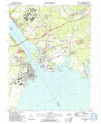 1992 Havre De Grace1993 Print · USGSThe northern reaches of the Chesapeake Bay are frozen in time in the early nineties, documenting the critical river crossings at Havre De Grace and Perryville. Researchers can trace the legacy of the Principio Furnace, locate the Concord Pt Lighthouse, and find family history at Mt Erin Cem or Patterson Cem.
 - 1998 Map of Havre De Grace, 2000 Print
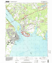 1998 Havre De Grace2000 Print · USGSThe Susquehanna meets the Chesapeake in this late-century study of a vital Maryland junction. Researchers can trace the legacy of the Perry Point VA Medical Center, locate Principio Furnace, and find family names at Patterson Cem or Mt Erin Cem.
End of results
Showing maps 1-2 of 2
Top cities near Jackson
- Elkton historical maps
- Aberdeen historical maps
- Havre de Grace historical maps
- New London Township historical maps
- Franklin Township historical maps
- Perryville historical maps
See more
Frequently asked questions
- What are the different types of historical maps available for Jackson?
- What is the oldest map of Jackson?
- Where can I purchase historical maps of Jackson for my home or office?
- Where can I download high-res historical maps of Jackson?
- Are there historical topographic maps available for Jackson?
- Is there historical aerial imagery available for Jackson?
- Where are historical maps of Jackson sourced from?