1910s Maps of Chapel Point, Maryland
Explore 1 historic maps of Chapel Point from the 1910s. These maps offer a rare glimpse into what life looked like during the 1910s — showing old roads, neighborhoods, homes, and landmarks that have changed or disappeared over time.
Whether you're researching your family's past, planning a metal detecting trip, or studying how Chapel Point's landscape evolved across the 1910s, these high-resolution maps are a powerful tool for exploring the history of this region.
- Focus on a specific era: All maps on this page are from the 1910s, giving you a focused view of this time period.
- See what’s changed: Compare century-old streets, trails, and buildings to today's modern landscape using overlays and satellite layers.
- Research with precision: Use these maps for genealogy, historical research, land use analysis, or educational projects.
- View, download, or print: Maps are fully viewable online in high resolution, and can be downloaded or printed for your own records.
Start exploring Chapel Point's history through authentic maps from the 1910s. This is your window into the past.
Chapel Point, MD maps
(1)- 1913 Map of Nanjemoy
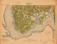 1913 Nanjemoy1913 Print · USGSThe Nanjemoy peninsula in the early nineteen-hundreds was a world of tidal creeks and tobacco landings. Researchers can trace the rural fabric of Charles County through family-named landmarks like Mudds Marsh and community hubs such as Durham Church and Green Leek School.3 unique versions available
End of results
Showing maps 1-1 of 1
Top cities near Chapel Point
- Waldorf historical maps
- Woodbridge historical maps
- Lorton historical maps
- Bennsville historical maps
- Accokeek historical maps
- La Plata historical maps
See more
Frequently asked questions
- What are the different types of historical maps available for Chapel Point?
- What is the oldest map of Chapel Point?
- Where can I purchase historical maps of Chapel Point for my home or office?
- Where can I download high-res historical maps of Chapel Point?
- Are there historical topographic maps available for Chapel Point?
- Is there historical aerial imagery available for Chapel Point?
- Where are historical maps of Chapel Point sourced from?