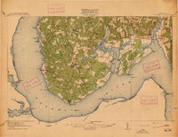
1913 Map of Nanjemoy
USGS Topo · Published 1913About this map
Potomac River shoreline and the deeply indented tidal creeks of Charles County define this pre-war survey of the Nanjemoy peninsula. The landscape is characterized by a network of rural settlements like Ironsides, Hilltop, and Cross Roads, connected by wagon roads that converge at local landmarks like Trappe Bridge. The influence of the river economy is evident in the numerous landings and wharves, such as Liverpool Wharf and Friendship Landing, which served as vital transit points for tobacco and goods before modern highway development.
Find a feature on this map
89 named features on this map. Tap any name to fly to it.
Don’t see what you’re looking for? This feature index may not catch every label — zoom into the map to look around manually.
Map Details
Editions of this 1913 Nanjemoy Map
3 editions found
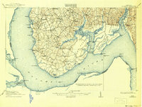
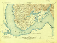
Other maps of this area

1889 · Fredericksburg
USGS Topo · 1:125,000

1890 · Mt. Vernon
USGS Topo · 1:125,000

1891 · Mt. Vernon
USGS Topo · 1:125,000

1892 · Fredericksburg
USGS Topo · 1:125,000

1892 · Brandywine
USGS Topo · 1:62,500

1894 · Wicomico
USGS Topo · 1:62,500

1894 · Fredericksburg
USGS Topo · 1:125,000

1894 · Mt. Vernon
USGS Topo · 1:125,000

1895 · Wicomico
USGS Topo · 1:62,500

1895 · Brandywine
USGS Topo · 1:62,500