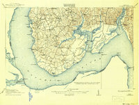
1913 Map of Nanjemoy
USGS Topo · Published 1942About this map
Nanjemoy and the surrounding riverfront of Charles County were defined by an intricate network of landings and small rural institutions just before World War I. The Potomac River dominates the landscape, creating a jagged coastline of coves and points like Mallows Bay and Maryland Pt, where the Maryland Pt Light guided maritime traffic. Inland, the community structure is visible through a high concentration of local schools including Green Leek School and Holly Springs School, and historic parishes such as Durham Church and St Thomas Church near the Port Tobacco River. This survey reveals the reliance on water-based commerce before the modern highway era, with prominent infrastructure like Liverpool Wharf and Friendship Landing serving as critical connection points for tobacco and local goods.
Find a feature on this map
86 named features on this map. Tap any name to fly to it.
Don’t see what you’re looking for? This feature index may not catch every label — zoom into the map to look around manually.
Map Details
Editions of this 1913 Nanjemoy Map
3 editions found

Other maps of this area

1889 · Fredericksburg
USGS Topo · 1:125,000

1890 · Mt. Vernon
USGS Topo · 1:125,000

1891 · Mt. Vernon
USGS Topo · 1:125,000

1892 · Fredericksburg
USGS Topo · 1:125,000

1892 · Brandywine
USGS Topo · 1:62,500

1894 · Wicomico
USGS Topo · 1:62,500

1894 · Fredericksburg
USGS Topo · 1:125,000

1894 · Mt. Vernon
USGS Topo · 1:125,000

1895 · Wicomico
USGS Topo · 1:62,500

1895 · Brandywine
USGS Topo · 1:62,500