1940s Maps of Church Creek, Maryland
Explore 5 historic maps of Church Creek from the 1940s. These maps offer a rare glimpse into what life looked like during the 1940s — showing old roads, neighborhoods, homes, and landmarks that have changed or disappeared over time.
Whether you're researching your family's past, planning a metal detecting trip, or studying how Church Creek's landscape evolved across the 1940s, these high-resolution maps are a powerful tool for exploring the history of this region.
- Focus on a specific era: All maps on this page are from the 1940s, giving you a focused view of this time period.
- See what’s changed: Compare century-old streets, trails, and buildings to today's modern landscape using overlays and satellite layers.
- Research with precision: Use these maps for genealogy, historical research, land use analysis, or educational projects.
- View, download, or print: Maps are fully viewable online in high resolution, and can be downloaded or printed for your own records.
Start exploring Church Creek's history through authentic maps from the 1940s. This is your window into the past.
Church Creek, MD maps
(5)- 1942 Map of Church Creek, 1958 Print
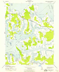 1942 Church Creek1958 Print · USGSThe Dorchester County tidewater region during the early 1940s is shown here through its intricate shoreline and rural peninsula settlements. Genealogists and historians can trace family roots through landmarks like Mace Cemetery, Gethsemane Church, and the village of Madison.2 unique versions available
 - 1942 Map of Golden Hill, 1961 Print
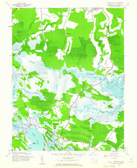 1942 Golden Hill1961 Print · USGSDorchester County's tidal wetlands and coastal settlements are captured here in the early 1940s. Genealogists and historians can trace the specific boundaries of Woolford Plantation Pt and locate rural hubs like Golden Hill and Riggins Corner.2 unique versions available
 - 1943 Map of Church Creek
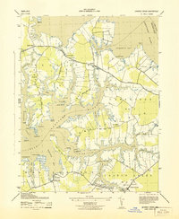 1943 Church Creek1943 Print · USGSDorchester County's intricate tidal landscape is captured here during the early 1940s, showing a world of peninsulas and creek-side settlements. Genealogists can locate family names at Trinity Cemetery and trace historical footprints in Madison, Woolford, and Dailsville.
 - 1943 Map of Golden Hill
 1943 Golden Hill1943 Print · USGSDorchester County's tidal wetlands and scattered hamlets are captured in this mid-century survey as they appeared during the war years. Genealogists can trace family locations and old landings near Golden Hill, Riggins Corner, and the historic Woolford Plantation Pt.
 - 1948 Map of Washington
 1948 Washington1948 Print · USGSThe Potomac and Chesapeake regions in the late 1940s reveal a landscape of expanding military reach and deep-rooted Tidewater settlements. Trace old rail corridors like the Richmond Fredericksburg & Potomac RR or locate landmarks like the Wakefield Washington Monument and St. Marys College.2 unique versions available
End of results
Showing maps 1-5 of 5
Top cities near Church Creek
- Cambridge historical maps
- Trappe historical maps
- Oxford historical maps
- Secretary historical maps
- East New Market historical maps
- Choptank historical maps
See more
Frequently asked questions
- What are the different types of historical maps available for Church Creek?
- What is the oldest map of Church Creek?
- Where can I purchase historical maps of Church Creek for my home or office?
- Where can I download high-res historical maps of Church Creek?
- Are there historical topographic maps available for Church Creek?
- Is there historical aerial imagery available for Church Creek?
- Where are historical maps of Church Creek sourced from?