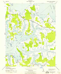
1942 Map of Church Creek
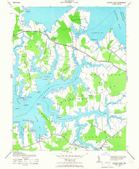
USGS Topo · Published 1958About this map
Hudson Neck and the surrounding peninsulas of Dorchester County are defined by their intimate connection to the Chesapeake's tidal waters, as seen in this 1942 survey. The landscape is a network of "necks" including Morris Neck and Bar Neck, where small farming and fishing communities like Madison and Lloyds thrived along the banks of the Choptank River. Coastal navigation was central to life here, evidenced by landmarks such as Travers Wharf and the prominent Madison Spire. Inland, a dense concentration of local houses of worship, including Gethsemane Church, Antioch Church, and Beckwith Church, points to the importance of community centers in these rural tidewater districts. The map also records family-linked sites like the Mace Cemetery, providing valuable data for genealogists interested in the early 20th-century Eastern Shore.
Find a feature on this map
78 named features on this map. Tap any name to fly to it.
Don’t see what you’re looking for? This feature index may not catch every label — zoom into the map to look around manually.
Map Details
Editions of this 1942 Church Creek Map
2 editions found
Other maps of this area

1892 · Drum Point
USGS Topo · 1:62,500

1893 · Sharps Island
USGS Topo · 1:62,500

1898 · Choptank
USGS Topo · 1:125,000

1898 · St. Marys
USGS Topo · 1:125,000

1901 · Drum Point
USGS Topo · 1:62,500

1904 · Sharps Island
USGS Topo · 1:62,500

1904 · Oxford
USGS Topo · 1:62,500

1905 · Crapo
USGS Topo · 1:62,500

1905 · Drum Point
USGS Topo · 1:62,500

1906 · St. Marys
USGS Topo · 1:125,000