1901 Map of Drum Point
USGS Topo · Published 1901About this map
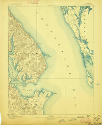
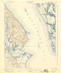
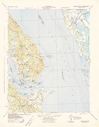
Solomons Island and the surrounding maritime landscape of the lower Patuxent River define this coastal study, conducted at a time when water travel was central to life in Southern Maryland. The survey captures the intricate shoreline of Solomons, a key fishing and harbor hub, and extends across the Chesapeake Bay to the eastern shore islands of Dorchester County. Essential navigational aids for bay traffic are documented, including the Drum Pt. L.H., Cove Pt. L.H., and Cedar Pt. L.H. stations. Inland, the map reveals a network of small landings and early settlements like St.Leonard and Jarboesville, while features such as Millstone Landing and Spencers Wharf underscore the importance of the river economy. On the eastern edge, the topography of Taylor Island and Barren I. is partially rendered, showing the early 20th-century footprint of these vulnerable bay islands.
Find a feature on this map
48 named features on this map. Tap any name to fly to it.
Don’t see what you’re looking for? This feature index may not catch every label — zoom into the map to look around manually.
Map Details
Editions of this 1901 Drum Point Map
This is the sole edition of this map. No revisions or reprints were ever made.
Historical Maps of Lexington Park Through Time
4 maps found