1940s Maps of Lovers Lane, Maryland
Explore 3 historic maps of Lovers Lane from the 1940s. These maps offer a rare glimpse into what life looked like during the 1940s — showing old roads, neighborhoods, homes, and landmarks that have changed or disappeared over time.
Whether you're researching your family's past, planning a metal detecting trip, or studying how Lovers Lane's landscape evolved across the 1940s, these high-resolution maps are a powerful tool for exploring the history of this region.
- Focus on a specific era: All maps on this page are from the 1940s, giving you a focused view of this time period.
- See what’s changed: Compare century-old streets, trails, and buildings to today's modern landscape using overlays and satellite layers.
- Research with precision: Use these maps for genealogy, historical research, land use analysis, or educational projects.
- View, download, or print: Maps are fully viewable online in high resolution, and can be downloaded or printed for your own records.
Start exploring Lovers Lane's history through authentic maps from the 1940s. This is your window into the past.
Lovers Lane, MD maps
(3)- 1943 Map of Cambridge, 1962 Print
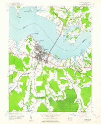 1943 Cambridge1962 Print · USGSThe Dorchester County seat in the early 1940s shows a bustling maritime and agricultural hub along the Choptank River. Researchers can trace old neighborhood boundaries near the State Hospital or locate rural landmarks like Christs Rock and Blackwater Sch.3 unique versions available
 - 1944 Map of Cambridge
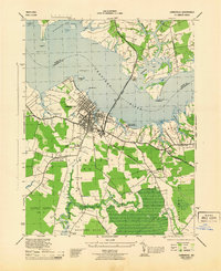 1944 Cambridge1944 Print · USGSDorchester County's waterfront and rural districts are captured here in the mid-1940s, from the busy docks of Cambridge to the marshes of the Blackwater River. Researchers can trace the layout of the Cambridge Branch railroad and find local landmarks like Christs Rock and the Blackwater School.
 - 1948 Map of Washington
 1948 Washington1948 Print · USGSThe Potomac and Chesapeake regions in the late 1940s reveal a landscape of expanding military reach and deep-rooted Tidewater settlements. Trace old rail corridors like the Richmond Fredericksburg & Potomac RR or locate landmarks like the Wakefield Washington Monument and St. Marys College.2 unique versions available
End of results
Showing maps 1-3 of 3
Top cities near Lovers Lane
- Easton historical maps
- Cambridge historical maps
- Hurlock historical maps
- Trappe historical maps
- Saint Michaels historical maps
- Oxford historical maps
See more
Frequently asked questions
- What are the different types of historical maps available for Lovers Lane?
- What is the oldest map of Lovers Lane?
- Where can I purchase historical maps of Lovers Lane for my home or office?
- Where can I download high-res historical maps of Lovers Lane?
- Are there historical topographic maps available for Lovers Lane?
- Is there historical aerial imagery available for Lovers Lane?
- Where are historical maps of Lovers Lane sourced from?