1980s Maps of Howard County, Maryland
Explore 14 historic maps of Howard County from the 1980s. These maps offer a rare glimpse into what life looked like during the 1980s — showing old roads, neighborhoods, homes, and landmarks that have changed or disappeared over time.
Whether you're researching your family's past, planning a metal detecting trip, or studying how Howard County's landscape evolved across the 1980s, these high-resolution maps are a powerful tool for exploring the history of this region.
- Focus on a specific era: All maps on this page are from the 1980s, giving you a focused view of this time period.
- See what’s changed: Compare century-old streets, trails, and buildings to today's modern landscape using overlays and satellite layers.
- Research with precision: Use these maps for genealogy, historical research, land use analysis, or educational projects.
- View, download, or print: Maps are fully viewable online in high resolution, and can be downloaded or printed for your own records.
Start exploring Howard County's history through authentic maps from the 1980s. This is your window into the past.
Howard County, MD maps
(14)- 1981 Map of Woodbine, 1986 Print
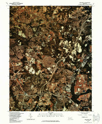
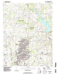
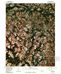 1981 Woodbine1986 Print · USGSHoward County's agricultural landscape is seen in transition during the early eighties, showcasing a patchwork of farms and woodland. Genealogists and local historians can trace the rural layouts of Lisbon, Woodbine, and the area around Cattail Creek.
 - 1981 Map of Clarksville, 1986 Print
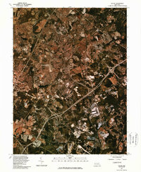
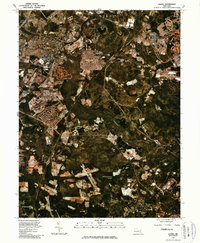
 1981 Clarksville1986 Print · USGSHoward County's landscape undergoes a transformation in the early eighties as suburban growth meets rural Maryland. Trace the development of Columbia and Clarksville alongside the waters of the Rocky Gorge Reservoir.
 - 1981 Map of Savage, 1986 Print
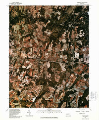
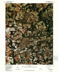
 1981 Savage1986 Print · USGSDuring the early 1980s, Howard County saw the rapid expansion of planned communities and transit corridors. Genealogists and historians can trace the growth of Columbia and locate the historic footprints of Savage, Jessup, and the Baltimore Washington Parkway.
 - 1981 Map of Sykesville, 1986 Print
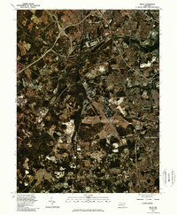
 1981 Sykesville1986 Print · USGSMaryland's changing rural landscape is captured in the early eighties as agricultural fields and suburban expansion meet. Researchers can trace land use and property boundaries around Sykesville and the forks of the Little Patuxent River.
 - 1981 Map of Beltsville, 1986 Print
 1981 Beltsville1986 Print · USGSMaryland's suburban corridor was rapidly maturing in the early eighties as highway networks integrated the communities between D.C. and Baltimore. Genealogists and local researchers can trace residential growth from Beltsville and Laurel to the borders of Greenbelt.
 - 1981 Map of Laurel, 1986 Print
 1981 Laurel1986 Print · USGSThe Patuxent River valley in the early 1980s reveals a Maryland landscape in the midst of significant suburban transformation. Researchers can trace the development of Laurel and Maryland City alongside water landmarks like Cash Lake and the Baltimore Washington Parkway.
 - 1981 Map of Damascus, 1986 Print
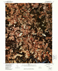
 1981 Damascus1986 Print · USGSDamascus and Mount Airy appear at the start of the 1980s in this detailed orthophoto study of the Maryland Piedmont. Researchers can trace land use patterns and property boundaries near the Patuxent River, Bennett Creek, and Cedar Heights.
 - 1981 Map of Sandy Spring, 1986 Print
 1981 Sandy Spring1986 Print · USGSMontgomery County in the early eighties exhibits a landscape of evolving farmland and emerging residential hubs. Trace the historical boundaries of rural Maryland through the aerial footprints of Brookeville, Sandy Spring, and the waters of the Triadelphia Reservoir.
 - 1981 Map of Relay, 1986 Print
 1981 Relay1986 Print · USGSMaryland's transportation corridor is captured in the early eighties as suburban expansion and aviation infrastructure began to reshape the region. Trace the footprints of Relay and Linthicum Heights or the massive layout of the Baltimore Washington International Airport.
 - 1982 Map of Ellicott City, 1986 Print
 1982 Ellicott City1986 Print · USGSMaryland's Piedmont landscape is captured in the early eighties as suburban growth began to surround the historic river corridor. Genealogists and researchers can trace property changes near Ellicott City or along the winding Patapsco River and Hebbville.
 - 1984 Map of Baltimore
 1984 Baltimore1984 Print · USGSThe Baltimore and Annapolis corridor in the mid-eighties shows a landscape of rapid suburban growth and deep-seated maritime history. Researchers can trace the massive footprints of the U S Naval Academy, Fort George G Meade, and Goddard Space Flight Ctr.
 - 1984 Map of Frederick, 1985 Print
 1984 Frederick1985 Print · USGSMaryland's Piedmont and the Potomac River valley are shown here in the mid-eighties as suburban growth began to meet historic rural landscapes. Genealogists and historians can trace the paths of the Baltimore and Ohio RR or locate the boundaries of Antietam National Battlefield and Fort Detrick.
 - 1988 Map of Sandy Spring, 1996 Print
 1988 Sandy Spring1996 Print · USGSMontgomery County was transitioning from its rural origins into a suburban residential landscape in the late eighties. Researchers can trace historic communities like Olney and Sandy Spring or find landmarks like Mt Zion Church and Camp Bennett.
 - 1989 Map of Baltimore
 1989 Baltimore1989 Print · USGSThe Mid-Atlantic corridor in the late eighties is captured here, from the Baltimore harbor to the Blue Ridge foothills. Researchers can trace the sprawling footprints of Aberdeen Proving Ground, the historic grounds of Gettysburg National Military Park, and the winding Susquehanna River.
End of results
Showing maps 1-14 of 14
Top cities of Howard County
- Columbia historical maps
- Ellicott City historical maps
- Clarksville historical maps
- Dayton historical maps
Frequently asked questions
- What are the different types of historical maps available for Howard County?
- What is the oldest map of Howard County?
- Where can I purchase historical maps of Howard County for my home or office?
- Where can I download high-res historical maps of Howard County?
- Are there historical topographic maps available for Howard County?
- Is there historical aerial imagery available for Howard County?
- Where are historical maps of Howard County sourced from?