1950s Maps of Mount Airy, Maryland
Explore 6 historic maps of Mount Airy from the 1950s. These maps offer a rare glimpse into what life looked like during the 1950s — showing old roads, neighborhoods, homes, and landmarks that have changed or disappeared over time.
Whether you're researching your family's past, planning a metal detecting trip, or studying how Mount Airy's landscape evolved across the 1950s, these high-resolution maps are a powerful tool for exploring the history of this region.
- Focus on a specific era: All maps on this page are from the 1950s, giving you a focused view of this time period.
- See what’s changed: Compare century-old streets, trails, and buildings to today's modern landscape using overlays and satellite layers.
- Research with precision: Use these maps for genealogy, historical research, land use analysis, or educational projects.
- View, download, or print: Maps are fully viewable online in high resolution, and can be downloaded or printed for your own records.
Start exploring Mount Airy's history through authentic maps from the 1950s. This is your window into the past.
Mount Airy, MD maps
(6)- 1950 Map of Libertytown
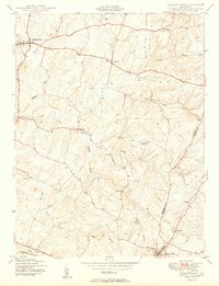 1950 Libertytown1950 Print · USGSMaryland's Piedmont region is captured here at mid-century, showing the rural landscapes of Frederick and Carroll Counties. Genealogists can locate family-named landmarks and institutions like Ridge Sch No 4, the Lime Mill, and settlements including Dorceytown and Woodville.2 unique versions available
 - 1950 Map of Damascus
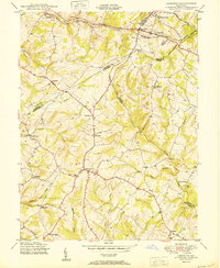 1950 Damascus1950 Print · USGSMid-century Maryland rural life is captured here at the intersection of four counties as agricultural communities thrived. Genealogists can trace family lands near Damascus or locate early settlements like Bartholows and Browningsville along the Baltimore and Ohio RR.2 unique versions available
 - 1950 Map of Woodbine
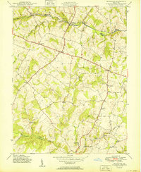 1950 Woodbine1950 Print · USGSMid-century Howard County remains a landscape of independent milling hubs and quiet crossroads hamlets. Trace the heritage of family operations like Hipsleys Mill and Roxbury Mills, or locate early rural school sites such as Mt Gregory Sch.2 unique versions available
 - 1954 Map of Baltimore
 1954 Baltimore1954 Print · USGSThe Mid-Atlantic region in the early fifties shows a landscape of growing suburban centers and heavy rail corridors. Trace mid-century transit networks and military landmarks from the Aberdeen Proving Ground to the Gettysburg National Military Park.
 - 1956 Map of Baltimore
 1956 Baltimore1956 Print · USGSMid-century Maryland and Pennsylvania are captured here during a period of massive suburban and military growth across the Chesapeake region. Genealogists and historians can trace the rail corridors of the Baltimore & Ohio RR and locate landmarks like Fort McHenry or the Aberdeen Proving Ground.
 - 1957 Map of Baltimore, 1964 Print
 1957 Baltimore1964 Print · USGSMaryland and Southern Pennsylvania are shown during the mid-century expansion of the Baltimore-Washington corridor. Researchers can trace the extensive rail lines of the Baltimore & Ohio RR and locate sites like Fort Detrick and Gettysburg National Military Park.5 unique versions available
End of results
Showing maps 1-6 of 6
Top cities near Mount Airy
- Germantown historical maps
- Frederick historical maps
- Gaithersburg historical maps
- Montgomery Village historical maps
- Eldersburg historical maps
- Westminster historical maps
See more
Top neighborhoods of Mount Airy
- Merridale Gardens historical maps
- Poulsen Heights historical maps
- Merridale historical maps
- Conestoga Heights historical maps
- Dorceytown historical maps
- Mount Airy Village West historical maps
See more
Frequently asked questions
- What are the different types of historical maps available for Mount Airy?
- What is the oldest map of Mount Airy?
- Where can I purchase historical maps of Mount Airy for my home or office?
- Where can I download high-res historical maps of Mount Airy?
- Are there historical topographic maps available for Mount Airy?
- Is there historical aerial imagery available for Mount Airy?
- Where are historical maps of Mount Airy sourced from?