1950s Maps of Upper Marlboro, Maryland
Explore 3 historic maps of Upper Marlboro from the 1950s. These maps offer a rare glimpse into what life looked like during the 1950s — showing old roads, neighborhoods, homes, and landmarks that have changed or disappeared over time.
Whether you're researching your family's past, planning a metal detecting trip, or studying how Upper Marlboro's landscape evolved across the 1950s, these high-resolution maps are a powerful tool for exploring the history of this region.
- Focus on a specific era: All maps on this page are from the 1950s, giving you a focused view of this time period.
- See what’s changed: Compare century-old streets, trails, and buildings to today's modern landscape using overlays and satellite layers.
- Research with precision: Use these maps for genealogy, historical research, land use analysis, or educational projects.
- View, download, or print: Maps are fully viewable online in high resolution, and can be downloaded or printed for your own records.
Start exploring Upper Marlboro's history through authentic maps from the 1950s. This is your window into the past.
Upper Marlboro, MD maps
(3)- 1957 Map of Bristol
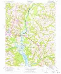 1957 Bristol1957 Print · USGSThe riverfront landings and rail corridors of Prince George's and Anne Arundel counties are well-defined in this mid-century survey. Genealogists and local historians can trace the foundations of Upper Marlboro and identify rural landmarks like Wesley Chapel, Waysons Corner, and the Marlboro Sta depot.5 unique versions available
 - 1957 Map of Upper Marlboro, 1958 Print
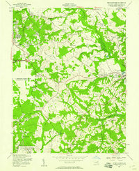 1957 Upper Marlboro1958 Print · USGSPrince George's County at the dawn of the Space Age shows a unique mix of Maryland tobacco heritage and modern military growth. Genealogists and local historians can trace old property lines and landmarks like Mt Airy and the Old Railroad Grade.2 unique versions available
 - 1957 Map of Washington, 1966 Print
 1957 Washington1966 Print · USGSThe mid-Atlantic region during the mid-fifties and early sixties reveals a landscape of growing suburbs and vital military outposts. Researchers can trace historic river towns and shorelines from Alexandria to the Hooper Islands and St Clements Island.5 unique versions available
End of results
Showing maps 1-3 of 3
Top cities near Upper Marlboro
- Washington historical maps
- Waldorf historical maps
- Silver Spring historical maps
- Bowie historical maps
- Clinton historical maps
- Annapolis historical maps
See more
Frequently asked questions
- What are the different types of historical maps available for Upper Marlboro?
- What is the oldest map of Upper Marlboro?
- Where can I purchase historical maps of Upper Marlboro for my home or office?
- Where can I download high-res historical maps of Upper Marlboro?
- Are there historical topographic maps available for Upper Marlboro?
- Is there historical aerial imagery available for Upper Marlboro?
- Where are historical maps of Upper Marlboro sourced from?