1950s Maps of Pine Cove, Maryland
Explore 5 historic maps of Pine Cove from the 1950s. These maps offer a rare glimpse into what life looked like during the 1950s — showing old roads, neighborhoods, homes, and landmarks that have changed or disappeared over time.
Whether you're researching your family's past, planning a metal detecting trip, or studying how Pine Cove's landscape evolved across the 1950s, these high-resolution maps are a powerful tool for exploring the history of this region.
- Focus on a specific era: All maps on this page are from the 1950s, giving you a focused view of this time period.
- See what’s changed: Compare century-old streets, trails, and buildings to today's modern landscape using overlays and satellite layers.
- Research with precision: Use these maps for genealogy, historical research, land use analysis, or educational projects.
- View, download, or print: Maps are fully viewable online in high resolution, and can be downloaded or printed for your own records.
Start exploring Pine Cove's history through authentic maps from the 1950s. This is your window into the past.
Pine Cove, MD maps
(5)- 1951 Map of Barclay
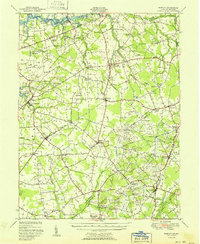 1951 Barclay1951 Print · USGSMid-century Queen Anne's County is captured here in its prime agricultural era, just as modern drainage was reshaping the Delmarva landscape. Genealogists can trace family names at Hackett Corners or locate landmarks like St Gertrude Academy and the Pennsylvania rail line.2 unique versions available
 - 1955 Map of Wilmington
 1955 Wilmington1955 Print · USGSThe Delaware Valley and Jersey Shore are seen here during the mid-fifties era of rapid suburban expansion and highway development. You can trace the path of the New Jersey Turnpike, locate the Fort Dix Military Reservation, or explore the rail networks of the Pennsylvania Railroad.
 - 1957 Map of Wilmington
 1957 Wilmington1957 Print · USGSThe mid-Atlantic coastal plain comes alive in the mid-fifties as the New Jersey Turnpike and Garden State Parkway redefine travel. Researchers can trace the rail-to-road transition and find landmarks like Ship John Shoal Light and the Fort Dix Military Reservation.2 unique versions available
 - 1958 Map of Church Hill, 1959 Print
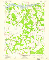 1958 Church Hill1959 Print · USGSQueen Anne's County life in the late fifties centered on the Chester River landings and crossroads hamlets. Researchers can trace family history at Boyer Chapel and Thomas Cem, or locate historic river points like Deep Landing.2 unique versions available
 - 1959 Map of Wilmington
 1959 Wilmington1959 Print · USGSThe Delaware Valley and Jersey Shore are seen here in the late fifties, during a period of massive suburban and highway expansion. Researchers can trace mid-century infrastructure like the N J Turnpike or locate coastal landmarks from Barnegat Bay to the Maurice River.3 unique versions available
End of results
Showing maps 1-5 of 5
Top cities near Pine Cove
- Middletown historical maps
- Chestertown historical maps
- Centreville historical maps
- Kingstown historical maps
- Cecilton historical maps
- Church Hill historical maps
See more
Frequently asked questions
- What are the different types of historical maps available for Pine Cove?
- What is the oldest map of Pine Cove?
- Where can I purchase historical maps of Pine Cove for my home or office?
- Where can I download high-res historical maps of Pine Cove?
- Are there historical topographic maps available for Pine Cove?
- Is there historical aerial imagery available for Pine Cove?
- Where are historical maps of Pine Cove sourced from?