1970s Maps of Upper Hill, Maryland
Explore 1 historic maps of Upper Hill from the 1970s. These maps offer a rare glimpse into what life looked like during the 1970s — showing old roads, neighborhoods, homes, and landmarks that have changed or disappeared over time.
Whether you're researching your family's past, planning a metal detecting trip, or studying how Upper Hill's landscape evolved across the 1970s, these high-resolution maps are a powerful tool for exploring the history of this region.
- Focus on a specific era: All maps on this page are from the 1970s, giving you a focused view of this time period.
- See what’s changed: Compare century-old streets, trails, and buildings to today's modern landscape using overlays and satellite layers.
- Research with precision: Use these maps for genealogy, historical research, land use analysis, or educational projects.
- View, download, or print: Maps are fully viewable online in high resolution, and can be downloaded or printed for your own records.
Start exploring Upper Hill's history through authentic maps from the 1970s. This is your window into the past.
Upper Hill, MD maps
(1)- 1972 Map of Marion, 1975 Print
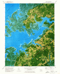 1972 Marion1975 Print · USGSSomerset County’s tidal necks and marshlands are captured in detail during the early seventies as the maritime economy shifted toward recreation and preservation. Researchers can trace family roots through landmarks like St Andrews Ch, the Pennsylvania Central rail line, and the old cemetery at Upper Hill.2 unique versions available
End of results
Showing maps 1-1 of 1
Top cities near Upper Hill
- Salisbury historical maps
- Fruitland historical maps
- Pocomoke City historical maps
- Princess Anne historical maps
- Crisfield historical maps
- Saxis historical maps
See more
Frequently asked questions
- What are the different types of historical maps available for Upper Hill?
- What is the oldest map of Upper Hill?
- Where can I purchase historical maps of Upper Hill for my home or office?
- Where can I download high-res historical maps of Upper Hill?
- Are there historical topographic maps available for Upper Hill?
- Is there historical aerial imagery available for Upper Hill?
- Where are historical maps of Upper Hill sourced from?