1940s Maps of Claiborne, Maryland
Explore 3 historic maps of Claiborne from the 1940s. These maps offer a rare glimpse into what life looked like during the 1940s — showing old roads, neighborhoods, homes, and landmarks that have changed or disappeared over time.
Whether you're researching your family's past, planning a metal detecting trip, or studying how Claiborne's landscape evolved across the 1940s, these high-resolution maps are a powerful tool for exploring the history of this region.
- Focus on a specific era: All maps on this page are from the 1940s, giving you a focused view of this time period.
- See what’s changed: Compare century-old streets, trails, and buildings to today's modern landscape using overlays and satellite layers.
- Research with precision: Use these maps for genealogy, historical research, land use analysis, or educational projects.
- View, download, or print: Maps are fully viewable online in high resolution, and can be downloaded or printed for your own records.
Start exploring Claiborne's history through authentic maps from the 1940s. This is your window into the past.
Claiborne, MD maps
(3)- 1942 Map of Claiborne, 1961 Print
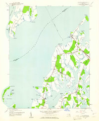 1942 Claiborne1961 Print · USGSCoastal Talbot County is captured here in the early 1940s, featuring the busy rail-to-ferry connection at Claiborne. Genealogists and historians can trace family locations near McDaniel and Bozman, or locate local landmarks like St Johns Ch and Wittman Sch.4 unique versions available
 - 1943 Map of Claiborne
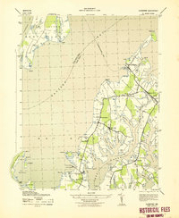 1943 Claiborne1943 Print · USGSTalbot County’s waterfront communities are captured in the early 1940s, showing a landscape shaped by the Chesapeake Bay and local rail lines. Genealogists and historians can trace the foundations of Claiborne and Sherwood, or locate landmarks like Wesley Church and the McDaniel RR Sta.
 - 1948 Map of Washington
 1948 Washington1948 Print · USGSThe Potomac and Chesapeake regions in the late 1940s reveal a landscape of expanding military reach and deep-rooted Tidewater settlements. Trace old rail corridors like the Richmond Fredericksburg & Potomac RR or locate landmarks like the Wakefield Washington Monument and St. Marys College.2 unique versions available
End of results
Showing maps 1-3 of 3
Top cities near Claiborne
- Annapolis historical maps
- Arnold historical maps
- Easton historical maps
- Cape Saint Claire historical maps
- Stevensville historical maps
- Centreville historical maps
See more
Frequently asked questions
- What are the different types of historical maps available for Claiborne?
- What is the oldest map of Claiborne?
- Where can I purchase historical maps of Claiborne for my home or office?
- Where can I download high-res historical maps of Claiborne?
- Are there historical topographic maps available for Claiborne?
- Is there historical aerial imagery available for Claiborne?
- Where are historical maps of Claiborne sourced from?