1940s Maps of Tricefield, Talbot County
Explore 3 historic maps of Tricefield from the 1940s. These maps offer a rare glimpse into what life looked like during the 1940s — showing old roads, neighborhoods, homes, and landmarks that have changed or disappeared over time.
Whether you're researching your family's past, planning a metal detecting trip, or studying how Tricefield's landscape evolved across the 1940s, these high-resolution maps are a powerful tool for exploring the history of this region.
- Focus on a specific era: All maps on this page are from the 1940s, giving you a focused view of this time period.
- See what’s changed: Compare century-old streets, trails, and buildings to today's modern landscape using overlays and satellite layers.
- Research with precision: Use these maps for genealogy, historical research, land use analysis, or educational projects.
- View, download, or print: Maps are fully viewable online in high resolution, and can be downloaded or printed for your own records.
Start exploring Tricefield's history through authentic maps from the 1940s. This is your window into the past.
Tricefield, Talbot County maps
(3)- 1942 Map of St. Michaels, 1961 Print
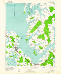 1942 St. Michaels1961 Print · USGSMid-century Talbot County is defined by its winding Chesapeake tributaries and the established harbor at St Michaels. Genealogists and historians can trace the rail-and-water corridors of the Baltimore and Eastern through settlements like Tunis Mills and Newcomb.3 unique versions available
 - 1943 Map of St. Michaels
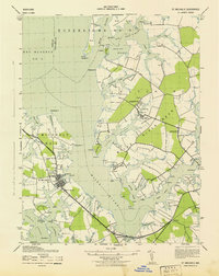 1943 St. Michaels1943 Print · USGSMaryland's Eastern Shore appears in the early 1940s as a landscape defined by its intricate waterways and rail-connected hamlets. Genealogists and historians can trace the foundations of local life through labels for St Michaels, Tunis Mills, and St Stevens Church.
 - 1948 Map of Washington
 1948 Washington1948 Print · USGSThe Potomac and Chesapeake regions in the late 1940s reveal a landscape of expanding military reach and deep-rooted Tidewater settlements. Trace old rail corridors like the Richmond Fredericksburg & Potomac RR or locate landmarks like the Wakefield Washington Monument and St. Marys College.2 unique versions available
End of results
Showing maps 1-3 of 3
Frequently asked questions
- What are the different types of historical maps available for Tricefield?
- What is the oldest map of Tricefield?
- Where can I purchase historical maps of Tricefield for my home or office?
- Where can I download high-res historical maps of Tricefield?
- Are there historical topographic maps available for Tricefield?
- Is there historical aerial imagery available for Tricefield?
- Where are historical maps of Tricefield sourced from?