1950s Maps of Washington County, Maryland
Explore 27 historic maps of Washington County from the 1950s. These maps offer a rare glimpse into what life looked like during the 1950s — showing old roads, neighborhoods, homes, and landmarks that have changed or disappeared over time.
Whether you're researching your family's past, planning a metal detecting trip, or studying how Washington County's landscape evolved across the 1950s, these high-resolution maps are a powerful tool for exploring the history of this region.
- Focus on a specific era: All maps on this page are from the 1950s, giving you a focused view of this time period.
- See what’s changed: Compare century-old streets, trails, and buildings to today's modern landscape using overlays and satellite layers.
- Research with precision: Use these maps for genealogy, historical research, land use analysis, or educational projects.
- View, download, or print: Maps are fully viewable online in high resolution, and can be downloaded or printed for your own records.
Start exploring Washington County's history through authentic maps from the 1950s. This is your window into the past.
Washington County, MD maps
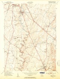
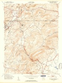
(27)- 1951 Map of Bellegrove, 1952 Print
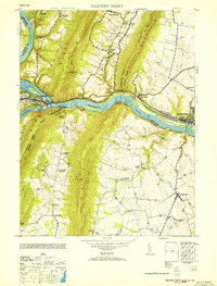
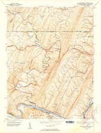 1951 Bellegrove1952 Print · USGSThe Maryland and Pennsylvania borderlands come alive in this mid-century survey of the ridges along the Potomac River. Genealogists and historians can trace family locations near Piney Plains Ch, the Woodmont Club, or the river landing at Pearre.7 unique versions available
 - 1951 Map of Cherry Run, 1953 Print
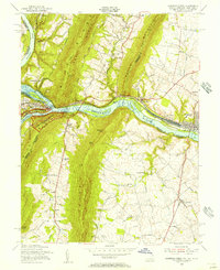
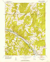 1951 Cherry Run1953 Print · USGSThe Potomac River valley and its rugged ridges are captured here during the early fifties as the region's transport network evolved. Genealogists and rail historians can trace the paths of the National Pike, the Baltimore and Ohio Railroad, and the Chesapeake and Ohio Canal (Abandoned).8 unique versions available
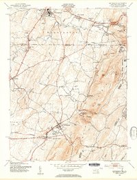
 - 1951 Map of Hancock, 1953 Print
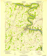
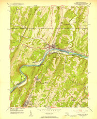 1951 Hancock1953 Print · USGSThe tri-state Potomac borderlands are captured here in the early fifties, showing the convergence of rail and river industry. Genealogists can trace family roots through Dogtown, Ridersville, and Johnsons Mill, or locate rural landmarks like the Westview Sch.4 unique versions available
 - 1952 Map of Cumberland
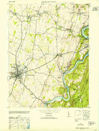
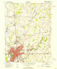
 1952 Cumberland1952 Print · USGSThe Potomac Highlands and the Shenandoah Valley are revealed in this early 1950s survey of the Appalachian interior. Researchers can trace the river-and-rail corridors connecting Cumberland, Winchester, and the recreational waters of Deep Creek Lake.
 - 1953 Map of Charles Town
 1953 Charles Town1953 Print · USGSJefferson County at mid-century centers on the rail junction of Charles Town and Ranson. Trace family roots at Zion Church or explore the industrial history of Millville and John Browns Cave.
 - 1953 Map of Harpers Ferry
 1953 Harpers Ferry1953 Print · USGSHarpers Ferry sits at the heart of this mid-century survey where the Potomac and Shenandoah rivers meet during a period of transition for the region's rail and canal heritage. Trace the grounds of Storer College and locate rural landmarks like Garretts Mill and the C and O Canal.
 - 1953 Map of Myersville, 1954 Print
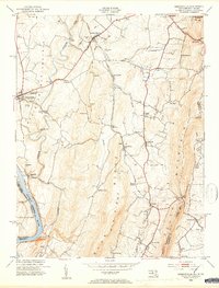
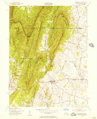
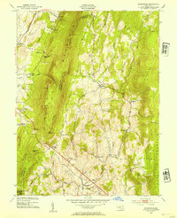 1953 Myersville1954 Print · USGSThe Frederick and Washington County line follows the crest of the Blue Ridge in the early fifties, where the Appalachian Trail winds past Annapolis Rock. Genealogists and historians can locate rural homesteads near Wolfsville Crossing, St Marks Ch, and Jerusalem.6 unique versions available
 - 1953 Map of Middletown, 1954 Print
 1953 Middletown1954 Print · USGSMaryland's Middletown Valley is shown here in the early fifties, caught between the parallel ridges of South and Catoctin Mountains. Genealogists and hikers can trace the Appalachian Trail past the Reno Monument or locate family roots near Burkittsville and Pleasant View Ch.6 unique versions available
 - 1953 Map of Mason-Dixon, 1954 Print
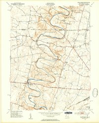 1953 Mason-Dixon1954 Print · USGSThe Mason-Dixon line bisects this fertile valley in the early 1950s, where the winding Conococheague Creek meets a network of country roads. Genealogists can trace old family sites and schools like Sunrise Sch, Steckerberger Sch, and the hamlet of Huyett.4 unique versions available
 - 1953 Map of Williamsport, 1954 Print
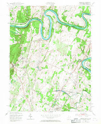
 1953 Williamsport1954 Print · USGSMaryland and West Virginia meet along the winding Potomac in the early fifties, capturing a landscape shaped by historical transit. Genealogists can trace family footprints near Williamsport, Downsville, and rural landmarks like Salem Ch or Greenlawn Cem.4 unique versions available
 - 1953 Map of Funkstown, 1954 Print
 1953 Funkstown1954 Print · USGSMaryland's Great Valley during the early fifties reveals a landscape of mill-lined creeks and emerging railroad sidings. Genealogists and researchers can trace local landmarks like Munroe Chapel, the industrial footprint of Rose Mill, and the community of Boonsboro.6 unique versions available
 - 1953 Map of Shepherdstown, 1954 Print
 1953 Shepherdstown1954 Print · USGSThe Potomac River and its dramatic loops at Terrapin Neck define the border between West Virginia and Maryland in the early fifties. Genealogists and local historians can trace landmarks like Shepherd College, Antietam Station, and Marvin Chapel.4 unique versions available
 - 1953 Map of Hagerstown, 1954 Print
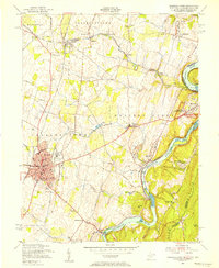
 1953 Hagerstown1954 Print · USGSHagerstown and the Maryland-Pennsylvania borderlands thrive during the mid-fifties as a hub of rail commerce and agricultural industry. Genealogists and historians can trace family locations through numerous rural schoolhouses like Greenmount Sch, local churches such as Paradise Ch, and the complex rail network of the Western Maryland and Pennsylvania lines.4 unique versions available
 - 1953 Map of Keedysville, 1954 Print
 1953 Keedysville1954 Print · USGSThe hallowed ground of the Antietam Battlefield and the ridges of South Mountain are captured here in the early fifties. Local historians can trace the Appalachian Trail, the Baltimore and Ohio rail line, and landmarks like Burnside Bridge.5 unique versions available
 - 1953 Map of Blue Ridge Summit, 1955 Print
 1953 Blue Ridge Summit1955 Print · USGSMaryland and Pennsylvania meet along the mountain crests in the early fifties, where the railroad and state line define local life. Genealogists and hikers can trace the Western Maryland tracks past Wesley Chapel, Charmian, and the Victor Cullen State Hospital.7 unique versions available
 - 1953 Map of Smithsburg, 1955 Print
 1953 Smithsburg1955 Print · USGSThe Maryland-Pennsylvania borderlands come alive in the early 1950s, showing the intersection of ridge-top recreation and valley agriculture. Researchers can trace the Mason and Dixon Line, locate historic sites like Pen Mar Park, and follow the Western Maryland rail line.5 unique versions available
 - 1954 Map of Baltimore
 1954 Baltimore1954 Print · USGSThe Mid-Atlantic region in the early fifties shows a landscape of growing suburban centers and heavy rail corridors. Trace mid-century transit networks and military landmarks from the Aberdeen Proving Ground to the Gettysburg National Military Park.
 - 1955 Map of Clear Spring, 1956 Print
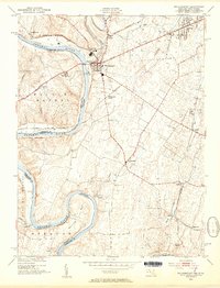
 1955 Clear Spring1956 Print · USGSThe Maryland-Pennsylvania borderlands are captured here in the mid-fifties, centered on the historic Mason and Dixon Line. Researchers and genealogists can trace the rural network of the National Pike through Kasiesville and locate family sites like Cushwa Cem.3 unique versions available
 - 1955 Map of Charles Town, 1956 Print
 1955 Charles Town1956 Print · USGSThe West Virginia panhandle meets the Blue Ridge in the mid-1950s, where the great river forks converge. Researchers can trace the industrial corridor of the Baltimore and Ohio railroad or locate landmarks like John Browns Cave and Zion Church.2 unique versions available
 - 1955 Map of Harpers Ferry, 1956 Print
 1955 Harpers Ferry1956 Print · USGSThe tri-state junction of West Virginia, Maryland, and Virginia is captured here during the mid-fifties as modern preservation began to take shape. Researchers can trace the Appalachian Trail, the historic Chesapeake and Ohio Canal, and local landmarks like Garretts Mill.2 unique versions available
 - 1955 Map of Hedgesville, 1967 Print
 1955 Hedgesville1967 Print · USGSThe West Virginia panhandle and Maryland border meet here in the mid-1950s along the winding Potomac River. Genealogists and historians can trace the paths of the Chesapeake and Ohio Canal, locate the Stonewall Jackson Monument, and explore settlements like Hedgesville and Bedington.2 unique versions available
 - 1956 Map of Baltimore
 1956 Baltimore1956 Print · USGSMid-century Maryland and Pennsylvania are captured here during a period of massive suburban and military growth across the Chesapeake region. Genealogists and historians can trace the rail corridors of the Baltimore & Ohio RR and locate landmarks like Fort McHenry or the Aberdeen Proving Ground.
 - 1956 Map of Cumberland, 1966 Print
 1956 Cumberland1966 Print · USGSThe tri-state Highlands in the mid-1950s show a landscape shaped by coal, timber, and the massive presence of the Baltimore & Ohio RR. Researchers can trace the industrial corridor from Cumberland through the Allegheny Mountains to mountain retreats like Deep Creek Lake.6 unique versions available
 - 1957 Map of Cumberland
 1957 Cumberland1957 Print · USGSThe Potomac River valley and the ridges of the Allegheny Front define this mid-century landscape at the intersection of Maryland, West Virginia, and Pennsylvania. Trace the steam-era rail lines of the Baltimore and Ohio RR or locate rural landmarks like St Stephens Church and Stony River Dam.
 - 1957 Map of Baltimore, 1964 Print
 1957 Baltimore1964 Print · USGSMaryland and Southern Pennsylvania are shown during the mid-century expansion of the Baltimore-Washington corridor. Researchers can trace the extensive rail lines of the Baltimore & Ohio RR and locate sites like Fort Detrick and Gettysburg National Military Park.5 unique versions available
Showing maps 1-25 of 27
Top cities of Washington County
- Hagerstown historical maps
- Halfway historical maps
- Robinwood historical maps
- Fountainhad-Orchard Hills historical maps
- Boonsboro historical maps
- Maugansville historical maps
See more
Frequently asked questions
- What are the different types of historical maps available for Washington County?
- What is the oldest map of Washington County?
- Where can I purchase historical maps of Washington County for my home or office?
- Where can I download high-res historical maps of Washington County?
- Are there historical topographic maps available for Washington County?
- Is there historical aerial imagery available for Washington County?
- Where are historical maps of Washington County sourced from?