1900s (20th Century) Maps of Boonsboro, Maryland
Explore 20 historic maps of Boonsboro from the 1900s (20th Century). These maps offer a rare glimpse into what life looked like during the 1900s — showing old roads, neighborhoods, homes, and landmarks that have changed or disappeared over time.
Whether you're researching your family's past, planning a metal detecting trip, or studying how Boonsboro's landscape evolved across the 1900s, these high-resolution maps are a powerful tool for exploring the history of this region.
- Focus on a specific era: All maps on this page are from the 1900s, giving you a focused view of this time period.
- See what’s changed: Compare century-old streets, trails, and buildings to today's modern landscape using overlays and satellite layers.
- Research with precision: Use these maps for genealogy, historical research, land use analysis, or educational projects.
- View, download, or print: Maps are fully viewable online in high resolution, and can be downloaded or printed for your own records.
Start exploring Boonsboro's history through authentic maps from the 1900s. This is your window into the past.
Boonsboro, MD maps
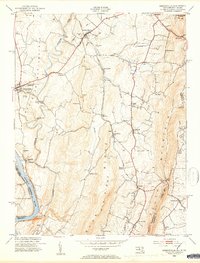
(20)- 1908 Map of Middletown
 1908 Middletown1908 Print · USGSThe Potomac River valley in the early twentieth century shows a landscape defined by the convergence of major rail lines and the historic Chesapeake and Ohio Canal. Genealogists and historians can trace the foundations of Eakles Mills, Burkittsville, and Washington Junction.
 - 1909 Map of Hagerstown
 1909 Hagerstown1909 Print · USGSHagerstown and the Antietam valley appear here during the height of the steam rail era, shortly after the turn of the century. Genealogists and historians can locate family homesteads near landmarks like St James Church, Smoketown School, and the Hagerstown and Boonsboro Ry.
 - 1910 Map of Antietam
 1910 Antietam1910 Print · USGSMaryland's borderlands and the Potomac River valley are captured here in the early twentieth century. Genealogists can locate family landmarks like Garretts Mill, trace the Chesapeake and Ohio Canal, or find historic sites including Dunkard Church.6 unique versions available
 - 1912 Map of Hagerstown
 1912 Hagerstown1912 Print · USGSMaryland's Cumberland Valley flourished as a rail and milling corridor during the early twentieth century. Genealogists can trace family names across dozens of rural landmarks like Strites Mill, Hallowell Church, and the Paradise School.9 unique versions available
 - 1942 Map of Hagerstown
 1942 Hagerstown1942 Print · USGSThe Cumberland Valley and Potomac corridor are captured here at the height of the Second World War rail-and-river era. Genealogists and historians can trace the industrial landscape of Richmond Furnace, the route of the Chesapeake and Ohio Canal, and the grounds of Camp Ritchie.
 - 1943 Map of Hagerstown
 1943 Hagerstown1943 Print · USGSThe Cumberland Valley was a critical wartime logistics hub in the 1940s, teeming with rail traffic and new military installations. Genealogists and historians can trace the Chesapeake and Ohio Canal or locate local landmarks like Richmond Furnace and Camp Ritchie.
 - 1944 Map of Keddysville
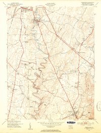
 1944 Keddysville1944 Print · USGSMaryland's Civil War landscape and rural hubs appear in transition during the mid-forties. Genealogists and historians can trace family locations near Antietam National Cemetery, old stops along the Baltimore and Ohio, or the path of the Chesapeake and Ohio Canal.2 unique versions available
 - 1944 Map of Funkstown
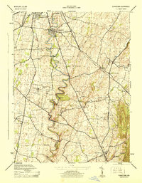 1944 Funkstown1944 Print · USGSWashington County during the Second World War was a region defined by its railroads and river-bound agriculture. Genealogists and historians can locate old landmarks like Lappans (Breathedsville P O), the Maryland State Penal Farm, and Doubs Mill.2 unique versions available
 - 1948 Map of Baltimore
 1948 Baltimore1948 Print · USGSMaryland and Pennsylvania crossroads are captured in the late 1940s, showing a landscape defined by historic rail lines and major military installations. Genealogists can trace family connections in Gettysburg, Westminster, and near the U.S. Naval Academy in Annapolis.2 unique versions available
 - 1953 Map of Funkstown, 1954 Print
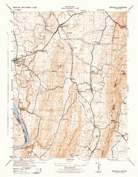
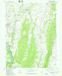
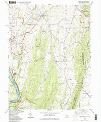
 1953 Funkstown1954 Print · USGSMaryland's Great Valley during the early fifties reveals a landscape of mill-lined creeks and emerging railroad sidings. Genealogists and researchers can trace local landmarks like Munroe Chapel, the industrial footprint of Rose Mill, and the community of Boonsboro.6 unique versions available
 - 1953 Map of Keedysville, 1954 Print
 1953 Keedysville1954 Print · USGSThe hallowed ground of the Antietam Battlefield and the ridges of South Mountain are captured here in the early fifties. Local historians can trace the Appalachian Trail, the Baltimore and Ohio rail line, and landmarks like Burnside Bridge.5 unique versions available
 - 1954 Map of Baltimore
 1954 Baltimore1954 Print · USGSThe Mid-Atlantic region in the early fifties shows a landscape of growing suburban centers and heavy rail corridors. Trace mid-century transit networks and military landmarks from the Aberdeen Proving Ground to the Gettysburg National Military Park.
 - 1956 Map of Baltimore
 1956 Baltimore1956 Print · USGSMid-century Maryland and Pennsylvania are captured here during a period of massive suburban and military growth across the Chesapeake region. Genealogists and historians can trace the rail corridors of the Baltimore & Ohio RR and locate landmarks like Fort McHenry or the Aberdeen Proving Ground.
 - 1957 Map of Baltimore, 1964 Print
 1957 Baltimore1964 Print · USGSMaryland and Southern Pennsylvania are shown during the mid-century expansion of the Baltimore-Washington corridor. Researchers can trace the extensive rail lines of the Baltimore & Ohio RR and locate sites like Fort Detrick and Gettysburg National Military Park.5 unique versions available
 - 1961 Map of Baltimore
 1961 Baltimore1961 Print · USGSMaryland and Pennsylvania are captured at a mid-century peak of industrial and military expansion. Genealogists and historians can trace rail corridors like the Western Maryland Ry or locate regional landmarks such as Camp Detrick and Kent Island.
 - 1978 Map of Keedysville
 1978 Keedysville1978 Print · USGSMaryland's Civil War landscape and river heritage are captured here in the late seventies. Family historians and researchers can trace local landmarks like Antietam Nat Cem, the Baltimore and Ohio Railroad, and the Townsend Monument.4 unique versions available
 - 1983 Map of Hagerstown, 1984 Print
 1983 Hagerstown1984 Print · USGSThe tri-state borderlands of Maryland, Pennsylvania, and West Virginia are shown in the early eighties as a hub of military installations and valley towns. Genealogists and historians can trace the landscape from Gettysburg National Military Park to the banks of the Potomac River.2 unique versions available
 - 1984 Map of Frederick, 1985 Print
 1984 Frederick1985 Print · USGSMaryland's Piedmont and the Potomac River valley are shown here in the mid-eighties as suburban growth began to meet historic rural landscapes. Genealogists and historians can trace the paths of the Baltimore and Ohio RR or locate the boundaries of Antietam National Battlefield and Fort Detrick.
 - 1989 Map of Baltimore
 1989 Baltimore1989 Print · USGSThe Mid-Atlantic corridor in the late eighties is captured here, from the Baltimore harbor to the Blue Ridge foothills. Researchers can trace the sprawling footprints of Aberdeen Proving Ground, the historic grounds of Gettysburg National Military Park, and the winding Susquehanna River.
 - 1994 Map of Keedysville, 1999 Print
 1994 Keedysville1999 Print · USGSThe Washington County countryside and the hallowed grounds of Antietam are captured here during the late twentieth century. Researchers can trace ancestral connections and local landmarks through detailed records of the Antietam Nat Cem, the old Rohrersville Sch, and settlements like Eakles Mills.
End of results
Showing maps 1-20 of 20
Top cities near Boonsboro
- Frederick historical maps
- Hagerstown historical maps
- Ballenger Creek historical maps
- Halfway historical maps
- Waynesboro historical maps
- Robinwood historical maps
See more
Frequently asked questions
- What are the different types of historical maps available for Boonsboro?
- What is the oldest map of Boonsboro?
- Where can I purchase historical maps of Boonsboro for my home or office?
- Where can I download high-res historical maps of Boonsboro?
- Are there historical topographic maps available for Boonsboro?
- Is there historical aerial imagery available for Boonsboro?
- Where are historical maps of Boonsboro sourced from?