
Loading...
Loading map...1908 Map of Middletown
USGS Topo · Published 1908About this map
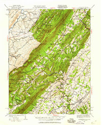
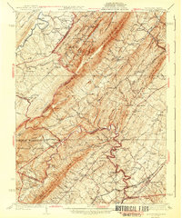
South Mountain and Catoctin Mountain dominate this landscape where the Potomac River carves its path along the Maryland and Virginia border. In this era, the river corridor serves as a vital artery for transport and industry, featuring the parallel routes of the Baltimore and Ohio RR and the Chesapeake and Ohio Canal. These twin infrastructure marvels converge at Washington Junction, a critical point for the Metropolitan Br and the Norfolk and Western Ry.
Find a feature on this map
36 named features on this map. Tap any name to fly to it.
Don’t see what you’re looking for? This feature index may not catch every label — zoom into the map to look around manually.
Map Details
Date Portrayed1908
Date Published1908
PublisherU.S. Geological Survey
Map TypeTopographic
Scale1:48,000
Physical Dimensions21.9 x 27.4 inches
Editions of this 1908 Middletown Map
This is the sole edition of this map. No revisions or reprints were ever made.
Historical Maps of Brunswick Through Time
8 maps found

Featured Locations
Source Details
SourceU.S. Geological Survey
CopyrightPublic Domain