1990s Maps of Ocean City, Maryland
Explore 3 historic maps of Ocean City from the 1990s. These maps offer a rare glimpse into what life looked like during the 1990s — showing old roads, neighborhoods, homes, and landmarks that have changed or disappeared over time.
Whether you're researching your family's past, planning a metal detecting trip, or studying how Ocean City's landscape evolved across the 1990s, these high-resolution maps are a powerful tool for exploring the history of this region.
- Focus on a specific era: All maps on this page are from the 1990s, giving you a focused view of this time period.
- See what’s changed: Compare century-old streets, trails, and buildings to today's modern landscape using overlays and satellite layers.
- Research with precision: Use these maps for genealogy, historical research, land use analysis, or educational projects.
- View, download, or print: Maps are fully viewable online in high resolution, and can be downloaded or printed for your own records.
Start exploring Ocean City's history through authentic maps from the 1990s. This is your window into the past.
Ocean City, MD maps
(3)- 1992 Map of Assawoman Bay
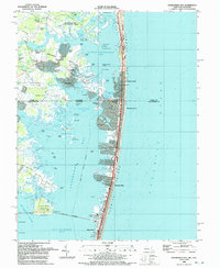 1992 Assawoman Bay1992 Print · USGSCoastal Delaware and Maryland meet in the early nineties along a landscape of shifting barrier islands and growing waterfront communities. Trace the shoreline development of Fenwick Island and Maryland Beach, or locate historic landmarks like the Fenwick Island Lighthouse and Peppers Landing.
 - 1997 Map of Assawoman Bay, 2000 Print
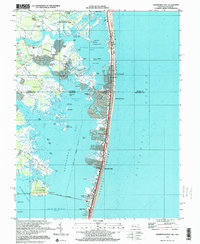 1997 Assawoman Bay2000 Print · USGSThe coastal borderlands of Delaware and Maryland are captured here just before the millennium, showing the dense development of the barrier islands. Genealogists and local historians can trace family landmarks like Drum Cem, the Fenwick Island Lighthouse, and the St George Ch.
 - 1998 Map of Ocean City, 2000 Print
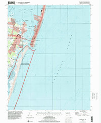 1998 Ocean City2000 Print · USGSOcean City and the Maryland coast are captured here in the late 1990s, showing the dense development of the barrier island alongside protected shorelines. Trace the urban grid from the Boardwalk to the Ocean City Inlet, or locate mainland landmarks like Captains Hill and the Ocean City Airport.
End of results
Showing maps 1-3 of 3
Top cities near Ocean City
- Ocean Pines historical maps
- West Ocean City historical maps
- Berlin historical maps
- Millsboro historical maps
- Selbyville historical maps
- Ocean View historical maps
See more
Top neighborhoods of Ocean City
- Bayside Keys historical maps
- Caine Harbor Mile historical maps
- Caine Woods historical maps
- Little Salisbury historical maps
- Montego Bay historical maps
- Montego Bay Mobile Home Park historical maps
See more
Frequently asked questions
- What are the different types of historical maps available for Ocean City?
- What is the oldest map of Ocean City?
- Where can I purchase historical maps of Ocean City for my home or office?
- Where can I download high-res historical maps of Ocean City?
- Are there historical topographic maps available for Ocean City?
- Is there historical aerial imagery available for Ocean City?
- Where are historical maps of Ocean City sourced from?