1970s Maps of Falmouth, Massachusetts
Explore 11 historic maps of Falmouth from the 1970s. These maps offer a rare glimpse into what life looked like during the 1970s — showing old roads, neighborhoods, homes, and landmarks that have changed or disappeared over time.
Whether you're researching your family's past, planning a metal detecting trip, or studying how Falmouth's landscape evolved across the 1970s, these high-resolution maps are a powerful tool for exploring the history of this region.
- Focus on a specific era: All maps on this page are from the 1970s, giving you a focused view of this time period.
- See what’s changed: Compare century-old streets, trails, and buildings to today's modern landscape using overlays and satellite layers.
- Research with precision: Use these maps for genealogy, historical research, land use analysis, or educational projects.
- View, download, or print: Maps are fully viewable online in high resolution, and can be downloaded or printed for your own records.
Start exploring Falmouth's history through authentic maps from the 1970s. This is your window into the past.
Falmouth, MA maps
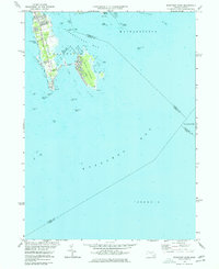
(11)- 1972 Map of Vineyard Haven, 1973 Print
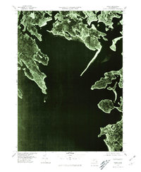
 1972 Vineyard Haven1973 Print · USGSMartha's Vineyard at the start of the 1970s shows a classic New England balance of maritime activity and rural interior. Genealogists can trace family names at Christiantown Memorial Cemetery or explore the early layouts of Vineyard Haven and West Tisbury.3 unique versions available
 - 1972 Map of Falmouth, 1974 Print
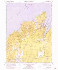
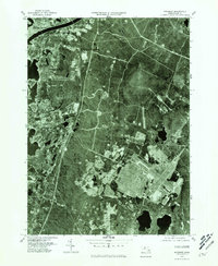
 1972 Falmouth1974 Print · USGSCoastal Barnstable County is documented here in the early seventies, capturing the intricate shoreline and residential growth of the Cape. Genealogists and local historians can locate specific landmarks including St Patricks Ch, Oak Grove Cem, and the Lawrence High Sch.3 unique versions available
 - 1974 Map of Cotuit, 1976 Print
 1974 Cotuit1976 Print · USGSCape Cod's southern shore in the mid-1970s shows a landscape of cranberry agriculture and coastal villages. Researchers can trace family landmarks and local institutions like the Old Indian Ch, the 4-H Club Camp, and the historic Cranberry Bogs near Marstons Mills.4 unique versions available
 - 1975 Map of Sconticut Neck, 1977 Print
 1975 Sconticut Neck1977 Print · USGSThe Fairhaven coastline at the mid-seventies is defined by the narrow reach of Sconticut Neck and the offshore community of West Island. Local researchers can trace the residential road networks and identify coastal landmarks like Silver Shell Beach, Wilbur Pt, and the Causeway.2 unique versions available
 - 1977 Map of Falmouth, 1981 Print
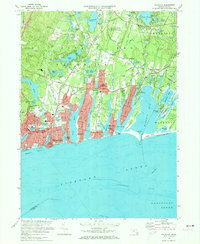
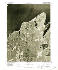
 1977 Falmouth1981 Print · USGSThe southern coast of the Cape during the late 1970s reveals a landscape of growing residential grids and winding coastal inlets. Researchers can trace the development of Falmouth and Teaticket or study the shorelines of Acapesket.
 - 1977 Map of Sconticut Neck, 1981 Print
 1977 Sconticut Neck1981 Print · USGSThe Bristol County coast appears as it did in the late seventies through this detailed aerial imagery. Local historians can trace the development patterns across Sconticut Neck, the connection to West Island, and the shoreline of Buzzards Bay.
 - 1977 Map of Onset, 1981 Print
 1977 Onset1981 Print · USGSCoastal Massachusetts at the end of the seventies reveals a detailed look at the developing shorelines and seasonal communities of the Buzzards Bay region. Researchers can trace the layout of waterfront settlements like Onset, Silver Beach, and the residential peninsulas of Great Neck.
 - 1977 Map of Pocasset, 1981 Print
 1977 Pocasset1981 Print · USGSCape Cod in the late seventies is seen through this detailed aerial survey of the western shoreline and canal entrance. Researchers can trace the development of Monument Beach and Pocasset or examine the infrastructure around the Cape Cod Canal.
 - 1977 Map of Vineyard Haven, 1981 Print
 1977 Vineyard Haven1981 Print · USGSMarthas Vineyard in the late seventies is captured in this detailed aerial perspective of its northern shores and inland villages. Researchers can trace the residential patterns of Vineyard Haven and the rural reaches of West Tisbury and Lake Tashmoo.
 - 1977 Map of Woods Hole, 1981 Print
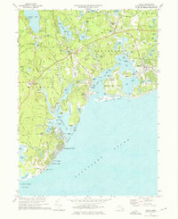
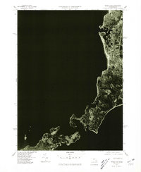 1977 Woods Hole1981 Print · USGSThe Cape Cod coastline near the end of the seventies shows the distinct village clusters and harbors before modern expansion. Trace the early footprints of Falmouth and Woods Hole, or explore the shores of Naushon Island.
 - 1977 Map of Cotuit, 1981 Print
 1977 Cotuit1981 Print · USGSCape Cod's south shore appears in striking photographic detail in the late seventies, showing the growing coastal communities and complex tidal inlets. Trace the 1977 footprints of Mashpee, Osterville, and the sandy reaches of Popponesset Beach.
End of results
Showing maps 1-11 of 11
Top cities near Falmouth
- Plymouth historical maps
- Wareham historical maps
- Sandwich historical maps
- Bourne historical maps
- Fairhaven historical maps
- Mashpee historical maps
See more
Top neighborhoods of Falmouth
- Old Silver Beach historical maps
- Saconesset Hills historical maps
- Sippewisset historical maps
- Mara Vista historical maps
- Megansett historical maps
- Davisville historical maps
See more
Frequently asked questions
- What are the different types of historical maps available for Falmouth?
- What is the oldest map of Falmouth?
- Where can I purchase historical maps of Falmouth for my home or office?
- Where can I download high-res historical maps of Falmouth?
- Are there historical topographic maps available for Falmouth?
- Is there historical aerial imagery available for Falmouth?
- Where are historical maps of Falmouth sourced from?