1800s (19th Century) Maps of Mashpee, Massachusetts
Explore 8 historic maps of Mashpee from the 1800s (19th Century). These maps offer a rare glimpse into what life looked like during the 1800s — showing old roads, neighborhoods, homes, and landmarks that have changed or disappeared over time.
Whether you're researching your family's past, planning a metal detecting trip, or studying how Mashpee's landscape evolved across the 1800s, these high-resolution maps are a powerful tool for exploring the history of this region.
- Focus on a specific era: All maps on this page are from the 1800s, giving you a focused view of this time period.
- See what’s changed: Compare century-old streets, trails, and buildings to today's modern landscape using overlays and satellite layers.
- Research with precision: Use these maps for genealogy, historical research, land use analysis, or educational projects.
- View, download, or print: Maps are fully viewable online in high resolution, and can be downloaded or printed for your own records.
Start exploring Mashpee's history through authentic maps from the 1800s. This is your window into the past.
Mashpee, MA maps
(8)- 1886 Map of Falmouth
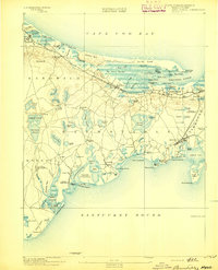
 1886 Falmouth1886 Print · USGSThe Cape Cod peninsula during the late nineteenth century shows a landscape transitioning between maritime tradition and rail-driven growth. Genealogists can trace family footprints in Waquoit Village, Teaticket, and Menauhant while following the Old Colony Railroad corridor.
 - 1887 Map of Marthas Vineyard
 1887 Marthas Vineyard1887 Print · USGSMartha's Vineyard in the late nineteenth century remains a landscape of maritime commerce and quiet island life. Genealogists can trace family names and early settlements from Cottage City and Edgartown to the rural roads of West Tisbury.
 - 1888 Map of Barnstable
 1888 Barnstable1888 Print · USGSMid-Cape Cod in the late nineteenth century was defined by its maritime commerce and the arrival of the rail. Genealogists and historians can trace the foundations of local life at the Indian Meeting House, Marston's Mills, and the Old Colony Railroad.
 - 1888 Map of Falmouth
 1888 Falmouth1888 Print · USGSThe Buzzards Bay coastline and upper Cape Cod are captured here in the late nineteenth century, documenting the critical arrival of the railroad. Researchers can trace the Old Colony Railroad to its terminus at Woods Holl or locate maritime landmarks like Wing's Neck Light.
 - 1889 Map of Marthas Vineyard
 1889 Marthas Vineyard1889 Print · USGSThe eastern shores of the Vineyard come alive in the late Victorian era, showcasing the early growth of Cottage City and Edgartown. Genealogists and historians can trace old road networks connecting West Tisbury to the coast and locate historic beacons like West Chop Light.
 - 1893 Map of Barnstable
 1893 Barnstable1893 Print · USGSCape Cod in the late nineteenth century remains a landscape of maritime navigation and early rail travel. Genealogists can trace family roots through sites like the Indian Meeting House, the Yarmouth Camp Grounds, and the Spring Hill Academy.8 unique versions available
 - 1893 Map of Falmouth
 1893 Falmouth1893 Print · USGSCape Cod's western shore and the upper reaches of Buzzards Bay are captured here in the late nineteenth century as rail travel transformed the coast. Genealogists can trace family names at Waquoit Village or follow the Old Colony Railroad through Woods Holl and Falmouth Station.9 unique versions available
 - 1894 Map of Marthas Vineyard, 1898 Print
 1894 Marthas Vineyard1898 Print · USGSMartha's Vineyard in the 1890s appears as a land of maritime necessity and early coastal villages. Genealogists can trace family settlements in Vineyard Haven and Edgartown or locate lighthouses like West Chop Light and Cape Poge Light.7 unique versions available
End of results
Showing maps 1-8 of 8
Top cities near Mashpee
- Plymouth historical maps
- Falmouth historical maps
- Yarmouth historical maps
- Wareham historical maps
- Sandwich historical maps
- Hyannis historical maps
See more
Top neighborhoods of Mashpee
- Maushop Village historical maps
- New Seabury historical maps
- Popponesset historical maps
- Popponesset Island historical maps
- Rock Landing historical maps
- Seabrook historical maps
See more
Frequently asked questions
- What are the different types of historical maps available for Mashpee?
- What is the oldest map of Mashpee?
- Where can I purchase historical maps of Mashpee for my home or office?
- Where can I download high-res historical maps of Mashpee?
- Are there historical topographic maps available for Mashpee?
- Is there historical aerial imagery available for Mashpee?
- Where are historical maps of Mashpee sourced from?