1970s Maps of Bowens Corners, Adams
Explore 2 historic maps of Bowens Corners from the 1970s. These maps offer a rare glimpse into what life looked like during the 1970s — showing old roads, neighborhoods, homes, and landmarks that have changed or disappeared over time.
Whether you're researching your family's past, planning a metal detecting trip, or studying how Bowens Corners's landscape evolved across the 1970s, these high-resolution maps are a powerful tool for exploring the history of this region.
- Focus on a specific era: All maps on this page are from the 1970s, giving you a focused view of this time period.
- See what’s changed: Compare century-old streets, trails, and buildings to today's modern landscape using overlays and satellite layers.
- Research with precision: Use these maps for genealogy, historical research, land use analysis, or educational projects.
- View, download, or print: Maps are fully viewable online in high resolution, and can be downloaded or printed for your own records.
Start exploring Bowens Corners's history through authentic maps from the 1970s. This is your window into the past.
Bowens Corners, Adams maps
(2)- 1973 Map of Windsor, 1975 Print
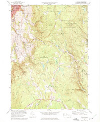 1973 Windsor1975 Print · USGSThe Berkshires transition from the industrial valley of Adams into the high forest lands of Savoy and Windsor during the early 1970s. Genealogists and hikers can trace family sites at Bellevue Cemetery or explore landmarks like Memorial Tower and Borden Mtn.2 unique versions available
 - 1975 Map of Windsor, 1981 Print
 1975 Windsor1981 Print · USGSThe Berkshire highlands are captured in the mid-seventies in this detailed aerial survey. Genealogists and local historians can trace the rural layouts of Windsor and Savoy, or locate the specific topography around Borden Mountain.
End of results
Showing maps 1-2 of 2
Top cities near Bowens Corners
- Pittsfield historical maps
- North Adams historical maps
- Bennington historical maps
- Adams historical maps
- Williamstown historical maps
- Hoosick historical maps
See more
Frequently asked questions
- What are the different types of historical maps available for Bowens Corners?
- What is the oldest map of Bowens Corners?
- Where can I purchase historical maps of Bowens Corners for my home or office?
- Where can I download high-res historical maps of Bowens Corners?
- Are there historical topographic maps available for Bowens Corners?
- Is there historical aerial imagery available for Bowens Corners?
- Where are historical maps of Bowens Corners sourced from?