Old Maps of Dalton, Massachusetts for Hiking & Exploration
Hike through history with 66 historic maps of Dalton. Explore old trails, ghost towns, and forgotten backroads — perfect for outdoor adventurers and local explorers.
- Rediscover forgotten places: Map out old mining camps, roads, and footpaths that no longer exist on modern maps.
- Layer with modern tools: Combine with LiDAR or satellite views to plan hikes through historical terrain.
- Made for exploration: Popular among hikers, overlanders, and local history lovers.
Use these maps to find adventure and explore the hidden past of Dalton.
Dalton, MA maps
(66)- 1886 Map of Greylock
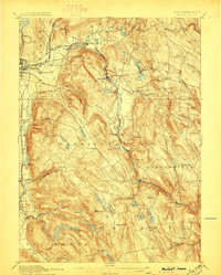
 1886 Greylock1886 Print · USGSThe northern Berkshires are captured here in the mid-1880s, dominated by the massif of Mt Greylock and the industrial valleys below. Genealogists and researchers can trace the vital rail links through the Hoosac Tunnel Line and find old neighborhood names like Blackington, Cheshire Harbor, and Savoy Hollow.
 - 1886 Map of Becket
 1886 Becket1886 Print · USGSThe Berkshire Highlands come into focus in the late nineteenth century, revealing a landscape of hill-town settlements and early industrial rail lines. Genealogists and historians can trace family locations in Becket Center, Middlefield, and Washington, or follow the Boston and Albany railroad as it passes Lenox Furnace.
 - 1888 Map of Becket
 1888 Becket1888 Print · USGSThe Berkshire highlands come alive in the late 1880s, showcasing a network of mountain settlements and vital rail corridors. Trace the path of the Boston and Albany Railroad through high-elevation stops like Washington Station and industrial sites at Lenox Furnace.
 - 1891 Map of Greylock
 1891 Greylock1891 Print · USGSThe northern Berkshires are captured here in the late nineteenth century as rail lines and textile centers transformed the rugged valley floor. Genealogists and hikers can trace old homesteads and landmarks like Mt Greylock, the Hoosac Tunnel Line, and the vanished site of Arnoldsville.
 - 1893 Map of Becket
 1893 Becket1893 Print · USGSThe Berkshire highlands in the 1890s reveal a landscape of mountain railroading and early industrial water power. Genealogists and historians can trace family locations near Washington Station, Lenox Furnace, and the early settlements of Becket Center.
 - 1893 Map of Greylock
 1893 Greylock1893 Print · USGSThe Northern Berkshires were at an industrial peak in the late 1800s, centered on the vital rail and water corridors of the Hoosic Valley. Researchers can trace the engineering of the Hoosac Tunnel Line and find historic mill settlements like Maple Grove and Cheshire Harbor.
 - 1897 Map of Becket
 1897 Becket1897 Print · USGSThe Berkshires at the end of the nineteenth century reveal a landscape of mountain rail lines and industrial waterpower. Genealogists and historians can trace family locations in Becket Center, Washington Station (P.O.), and Lenox Furnace.8 unique versions available
 - 1898 Map of Greylock
 1898 Greylock1898 Print · USGSThe Berkshire highlands at the close of the nineteenth century reveal a landscape of deep valleys and engineering feats. Trace the path of the Hoosac Tunnel or locate historic mill sites and rail stops in North Adams, Zylonite, and Cheshire.10 unique versions available
 - 1899 Map of Housatonic
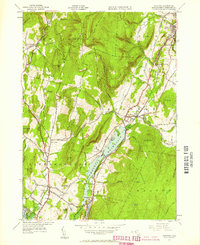
 1899 Housatonic1899 Print · USGSThe Berkshire hills at the close of the nineteenth century reveal a landscape of industrial hamlets and Shaker settlements. Trace the rail-and-river economy through Lenox Furnace, locate the historic Shaker Village, and find landmarks like Laura Tower.
 - 1900 Map of Taconic
 1900 Taconic1900 Print · USGSThe tri-state border region of the Taconic Mountains thrived at the turn of the century as a hub of rail travel and valley industry. Genealogists and historians can trace the early footprints of Hoosick Falls, Bennington, and the winding path of the Rutland R.R.4 unique versions available
 - 1900 Map of Housatonic
 1900 Housatonic1900 Print · USGSThe Berkshires and the Housatonic Valley are captured here at a moment of industrial and social transition during the late Victorian era. Genealogists and historians can trace the early rail networks of the Boston and Albany R.R. through old settlements like Shaker Village and Lenox Furnace.5 unique versions available
 - 1943 Map of Housatonic
 1943 Housatonic1943 Print · USGSThe Berkshires and the Housatonic Valley are captured during the war years, showing a landscape of traditional Shaker settlements and growing industrial centers. Trace the routes of the NY NH & H RR and explore sites like Shaker Village, Richmond Furnace, and Rockdale Mills.
 - 1944 Map of Windsor, 1958 Print
 1944 Windsor1958 Print · USGSBerkshire County in the mid-1940s reveals a rugged upland landscape of mountain peaks and winding river valleys before modern development. Genealogists and hikers can trace the path of the Appalachian Trail near Stafford Hill and locate long-standing landmarks like Tannery Falls and Savoy Center.
 - 1944 Map of Cheshire, 1958 Print
 1944 Cheshire1958 Print · USGSThe Hoosic River valley is captured here in the mid-1940s, showing a landscape defined by the Boston and Albany Railroad and upland dairy farming. Researchers can trace historic mill hamlets like Arnoldsville and Cheshire Harbor or locate the Stone Sch.2 unique versions available
 - 1944 Map of Pittsfield East, 1958 Print
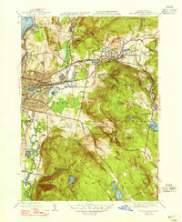
 1944 Pittsfield East1958 Print · USGSThe industrial heart of the Berkshires during the mid-1940s is defined here by the river-and-rail corridor connecting Pittsfield and Dalton. Local historians can trace the paths of the Boston and Albany railroad and locate landmarks like Wahconah Falls Brook and Silver Lake.
 - 1945 Map of Peru, 1958 Print
 1945 Peru1958 Print · USGSIn the Berkshire Highlands at the end of the Second World War, this landscape shows the quiet character of rural Massachusetts hill towns. Genealogists and hikers can trace the original paths of Buttermilk Road, the remote Peru Cem, and the historic transit line of the Boston and Albany RR.
 - 1946 Map of Windsor
 1946 Windsor1946 Print · USGSBerkshire County mountain life is captured here in the mid-1940s, showing a landscape of high ridges and rural outposts. Researchers can trace the original path of the Appalachian Trail or locate family sites near Bush Cem and Cherry Hill Sch.
 - 1946 Map of Cheshire
 1946 Cheshire1946 Print · USGSMid-century Berkshire County is captured here during the post-war era, showing the intersection of industrial rail lines and steep mountain terrain. Genealogists and historians can trace the Boston and Albany rail stops through Cheshire Harbor, Farnams, and the Stone Sch.
 - 1947 Map of Cheshire
 1947 Cheshire1947 Print · USGSBerkshire County at the end of the 1940s shows a landscape of mountain ridges and valley industry defined by the Hoosic River corridor. Researchers can trace the Boston and Albany Railroad past the Stone Sch and the waters of Cheshire Reservoir.3 unique versions available
 - 1947 Map of Pittsfield East
 1947 Pittsfield East1947 Print · USGSPost-war Berkshire County comes to life on this detailed map of the industrial and mountain corridors. Researchers can trace the Boston and Albany RR through Coltsville or follow the early Appalachian Trail past Day Mtn.3 unique versions available
 - 1947 Map of Windsor
 1947 Windsor1947 Print · USGSThe Hoosac Range heights in the late 1940s reveal a landscape of upland farms and mountain trails. Trace the early path of the Appalachian Trail across Weston Mountain and locate remote sites like Savoy Center and the Bush Cem.2 unique versions available
 - 1948 Map of Peru
 1948 Peru1948 Print · USGSThe high Berkshire hills are captured here just after the war, showing the mountain settlements of Peru and Hinsdale in great detail. Genealogists and local historians can trace family-named roads and remote burial grounds like Perry Cem, North Cem, and the rail stop at Washington Sta.2 unique versions available
 - 1948 Map of Albany, 1951 Print
 1948 Albany1951 Print · USGSThe Hudson and Connecticut River valleys are captured here in the late 1940s, showing the vital rail and water corridors of the Northeast. You can trace the Boston and Maine tracks past Mt Greylock or locate early settlements like Great Barrington and Bennington.
 - 1956 Map of Albany, 1968 Print
 1956 Albany1968 Print · USGSThe industrial heart of the Northeast is revealed in the mid-1950s, from the Hudson Valley to the Connecticut River. Researchers can trace the legacy of the Quabbin Reservoir, locate Westover Air Force Base, or follow the Rutland RR through the Green Mountains.2 unique versions available
 - 1957 Map of Albany
 1957 Albany1957 Print · USGSThe Tri-State region and Connecticut River Valley are captured here during a period of significant postwar growth and infrastructure expansion. Genealogists and historians can trace the rail-and-river economy through landmarks like the Boston and Maine railroad, Quabbin Reservoir, and Westover Air Force Base.
Showing maps 1-25 of 66
Top cities near Dalton
- Pittsfield historical maps
- North Adams historical maps
- Adams historical maps
- Williamstown historical maps
- Great Barrington historical maps
- Lee historical maps
See more
Top neighborhoods of Dalton
Frequently asked questions
- What are the different types of historical maps available for Dalton?
- What is the oldest map of Dalton?
- Where can I purchase historical maps of Dalton for my home or office?
- Where can I download high-res historical maps of Dalton?
- Are there historical topographic maps available for Dalton?
- Is there historical aerial imagery available for Dalton?
- Where are historical maps of Dalton sourced from?