1970s Maps of Camp Merrill, Pittsfield
Explore 2 historic maps of Camp Merrill from the 1970s. These maps offer a rare glimpse into what life looked like during the 1970s — showing old roads, neighborhoods, homes, and landmarks that have changed or disappeared over time.
Whether you're researching your family's past, planning a metal detecting trip, or studying how Camp Merrill's landscape evolved across the 1970s, these high-resolution maps are a powerful tool for exploring the history of this region.
- Focus on a specific era: All maps on this page are from the 1970s, giving you a focused view of this time period.
- See what’s changed: Compare century-old streets, trails, and buildings to today's modern landscape using overlays and satellite layers.
- Research with precision: Use these maps for genealogy, historical research, land use analysis, or educational projects.
- View, download, or print: Maps are fully viewable online in high resolution, and can be downloaded or printed for your own records.
Start exploring Camp Merrill's history through authentic maps from the 1970s. This is your window into the past.
Camp Merrill, Pittsfield maps
(2)- 1973 Map of Pittsfield East, 1975 Print
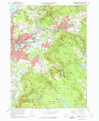 1973 Pittsfield East1975 Print · USGSThe industrial heart of the Berkshires comes into focus in the 1970s, as the mills of Dalton and the urban streets of Pittsfield meet the rising forest. Researchers can trace the path of the Appalachian Trail or locate family sites at Fairview Cem and St Helenas Chapel.2 unique versions available
 - 1975 Map of Pittsfield East, 1981 Print
 1975 Pittsfield East1981 Print · USGSThe Berkshire hills in the mid-seventies come into sharp focus in this aerial orthophoto of the area east of Pittsfield. Researchers can trace the industrial and residential corridors along the Housatonic River through Dalton and Hinsdale.
End of results
Showing maps 1-2 of 2
Top cities near Camp Merrill
- Pittsfield historical maps
- North Adams historical maps
- Sand Lake historical maps
- Adams historical maps
- Williamstown historical maps
- Dalton historical maps
See more
Frequently asked questions
- What are the different types of historical maps available for Camp Merrill?
- What is the oldest map of Camp Merrill?
- Where can I purchase historical maps of Camp Merrill for my home or office?
- Where can I download high-res historical maps of Camp Merrill?
- Are there historical topographic maps available for Camp Merrill?
- Is there historical aerial imagery available for Camp Merrill?
- Where are historical maps of Camp Merrill sourced from?