1800s (19th Century) Maps of Manchester-by-the-Sea, Massachusetts
Explore 5 historic maps of Manchester-by-the-Sea from the 1800s (19th Century). These maps offer a rare glimpse into what life looked like during the 1800s — showing old roads, neighborhoods, homes, and landmarks that have changed or disappeared over time.
Whether you're researching your family's past, planning a metal detecting trip, or studying how Manchester-by-the-Sea's landscape evolved across the 1800s, these high-resolution maps are a powerful tool for exploring the history of this region.
- Focus on a specific era: All maps on this page are from the 1800s, giving you a focused view of this time period.
- See what’s changed: Compare century-old streets, trails, and buildings to today's modern landscape using overlays and satellite layers.
- Research with precision: Use these maps for genealogy, historical research, land use analysis, or educational projects.
- View, download, or print: Maps are fully viewable online in high resolution, and can be downloaded or printed for your own records.
Start exploring Manchester-by-the-Sea's history through authentic maps from the 1800s. This is your window into the past.
Manchester-by-the-Sea, MA maps
(5)- 1886 Map of Gloucester
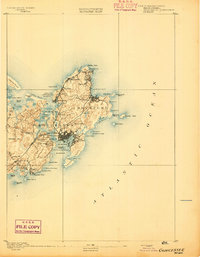
 1886 Gloucester1886 Print · USGSCape Ann at the close of the nineteenth century reveals a landscape defined by its deep granite quarries and world-famous fishing fleet. Trace the ancestral footprints of maritime families in Gloucester and Rockport, or locate long-lost stops like West Gloucester Station along the Boston and Maine Railroad.
 - 1888 Map of Gloucester
 1888 Gloucester1888 Print · USGSCape Ann's maritime landscape at the peak of the Victorian era shows a rugged coast of granite quarries and fishing ports. Trace the early tracks of the Boston and Maine Railroad and locate vanished landmarks like Freshwater Cove Village or the light at Thatchers Island.
 - 1888 Map of Salem
 1888 Salem1888 Print · USGSThe North Shore in the late nineteenth century is captured here in its era of peak rail development. Genealogists and historians can trace family-named sites like Doles Corner and institutions such as Dummer Academy or the Insane Asylum.
 - 1893 Map of Salem
 1893 Salem1893 Print · USGSCoastal Massachusetts at the end of the nineteenth century reveals a landscape defined by industrial rail lines and ancient marshlands. Genealogists and historians can trace family-named hills and early institutional sites like Dummer Academy, the Insane Asylum, and the Ipswich Light.11 unique versions available
 - 1893 Map of Gloucester
 1893 Gloucester1893 Print · USGSCape Ann's rugged maritime communities were firmly established by the 1890s, centered on the bustling port of Gloucester. Researchers can trace the coastal neighborhoods of Lanesville and Annisquam or locate family landmarks like Freshwater Cove Village and the Boston and Maine Railroad line.9 unique versions available
End of results
Showing maps 1-5 of 5
Top cities near Manchester-by-the-Sea
- Boston historical maps
- Lynn historical maps
- Revere historical maps
- Peabody historical maps
- Salem historical maps
- Beverly historical maps
See more
Top neighborhoods of Manchester-by-the-Sea
Frequently asked questions
- What are the different types of historical maps available for Manchester-by-the-Sea?
- What is the oldest map of Manchester-by-the-Sea?
- Where can I purchase historical maps of Manchester-by-the-Sea for my home or office?
- Where can I download high-res historical maps of Manchester-by-the-Sea?
- Are there historical topographic maps available for Manchester-by-the-Sea?
- Is there historical aerial imagery available for Manchester-by-the-Sea?
- Where are historical maps of Manchester-by-the-Sea sourced from?