Old Maps of Newbury, Massachusetts for Hiking & Exploration
Hike through history with 53 historic maps of Newbury. Explore old trails, ghost towns, and forgotten backroads — perfect for outdoor adventurers and local explorers.
- Rediscover forgotten places: Map out old mining camps, roads, and footpaths that no longer exist on modern maps.
- Layer with modern tools: Combine with LiDAR or satellite views to plan hikes through historical terrain.
- Made for exploration: Popular among hikers, overlanders, and local history lovers.
Use these maps to find adventure and explore the hidden past of Newbury.
Newbury, MA maps
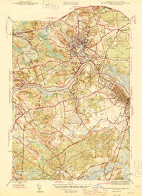
(53)- 1888 Map of Newburyport
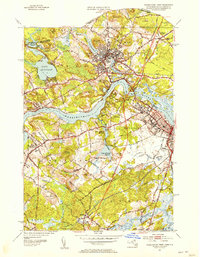
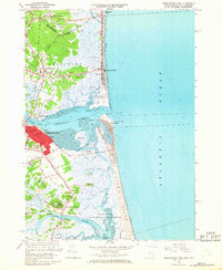
 1888 Newburyport1888 Print · USGSThe North Shore and Seacoast regions meet at the turn of the century along the Merrimac River. Trace the early rail lines of the Boston and Maine Railroad or locate coastal landmarks like the U.S. Life Saving Station and Range Light.
 - 1888 Map of Salem
 1888 Salem1888 Print · USGSThe North Shore in the late nineteenth century is captured here in its era of peak rail development. Genealogists and historians can trace family-named sites like Doles Corner and institutions such as Dummer Academy or the Insane Asylum.
 - 1890 Map of Newburyport
 1890 Newburyport1890 Print · USGSThe coastal borderlands of Massachusetts and New Hampshire are shown here during a peak era of maritime and rail activity. Genealogists and local historians can trace family-named sites across Newbury Old Town, Byfield, and the bustling docks at Salisbury Point.
 - 1893 Map of Salem
 1893 Salem1893 Print · USGSCoastal Massachusetts at the end of the nineteenth century reveals a landscape defined by industrial rail lines and ancient marshlands. Genealogists and historians can trace family-named hills and early institutional sites like Dummer Academy, the Insane Asylum, and the Ipswich Light.11 unique versions available
 - 1894 Map of Newburyport
 1894 Newburyport1894 Print · USGSCoastal Massachusetts and New Hampshire are captured here in the late nineteenth century, from the bustling riverfront of Newburyport to the marshes of Hampton. Genealogists and historians can trace rail lines, coastal landmarks like the U.S. Life Saving Station, and old neighborhoods in Amesbury or Newbury Old Town.7 unique versions available
 - 1917 Map of Salem
 1917 Salem1917 Print · USGSCoastal Massachusetts at the end of the Great War reveals a landscape of maritime commerce and rail-connected villages. Trace the local economy from Salem Harbor to Ipswich Light, or locate historic sites like Dummer Academy and the Insane Asylum.
 - 1919 Map of Salem
 1919 Salem1919 Print · USGSThe North Shore and its rail-connected towns are captured here during the height of the steam era. Genealogists and historians can trace the local landscape through landmarks like Dummer Academy, the Insane Asylum, and the vanished Box Factory.2 unique versions available
 - 1932 Map of Newburyport
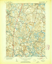
 1932 Newburyport1932 Print · USGSThe New Hampshire seacoast and southern Rockingham County are shown here in the early thirties, just as coastal recreation and inland farming reached a mature balance. Genealogists can locate family-named landmarks like Nason Corner, Dearborn Academy, and various district schools.4 unique versions available
 - 1934 Map of Exeter
 1934 Exeter1934 Print · USGSThe New Hampshire seacoast and Merrimack Valley met the Atlantic in the mid-thirties as a network of rail and river commerce. Genealogists can trace family lines through Newbury Old Town or locate historic institutions like Phillips Exeter Academy and Dearborn Academy.5 unique versions available
 - 1943 Map of Cape Ann
 1943 Cape Ann1943 Print · USGSCoastal Massachusetts and New Hampshire appear here during the wartime era, showing the maritime and rail infrastructure that defined the North Shore. Genealogists can trace family names across Asbury Grove, Merrimacport, and the Boston & Maine RR rail corridor.
 - 1944 Map of Georgetown
 1944 Georgetown1944 Print · USGSCoastal Massachusetts during the mid-forties reveals a landscape of wooded state forests and traditional village centers. Researchers can trace family roots through Harmony Cem, the halls of Dummer Academy, or along the old Boston and Maine rail line.2 unique versions available
 - 1944 Map of Newburyport West
 1944 Newburyport West1944 Print · USGSThe Lower Merrimack Valley at the height of the 1940s reveals a landscape of manufacturing towns and riverside villages. Genealogists can trace family footprints across Union Cem, Bridge Street Cem, and the old neighborhoods of Amesbury and Newburyport.3 unique versions available
 - 1945 Map of Newburyport East
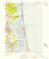
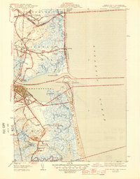 1945 Newburyport East1945 Print · USGSThe Massachusetts and New Hampshire borderlands meet the Atlantic at the height of the war years, showing a landscape defined by tidal rivers and coastal reaches. Genealogists and historians can trace Newbury Old Town, the Newburyport LH, and the CCC Camp near Salisbury.2 unique versions available
 - 1945 Map of Ipswich
 1945 Ipswich1945 Print · USGSIpswich and the surrounding Essex County coast are detailed here in the mid-1940s, highlighting a landscape defined by tidal rivers and barrier islands. Genealogists and historians can locate family landmarks such as Heartbreak Hill, the Mount Cem, and the Boston and Maine Railroad corridor.3 unique versions available
 - 1948 Map of Boston
 1948 Boston1948 Print · USGSEastern Massachusetts and southern New Hampshire appear at an industrial peak in the late 1940s, just as suburban growth began to accelerate. Genealogists and historians can trace rail lines like the Boston and Albany RR or locate coastal landmarks like Graves Lighthouse and Fort Devens.2 unique versions available
 - 1950 Map of Ipswich, 1956 Print
 1950 Ipswich1956 Print · USGSCoastal Massachusetts is seen here in the mid-century as a land of expansive salt marshes and historic harbor towns. Genealogists and historians can trace family-named hills and early settlements from Ipswich and Rowley to landmarks like Castle Hill and Nourse Cem.3 unique versions available
 - 1952 Map of Newburyport West, 1953 Print
 1952 Newburyport West1953 Print · USGSThe Merrimack River valley in the early fifties shows a landscape of established river towns and growing transit corridors. Genealogists can locate family burial sites at Sawyers Hill Burying Ground or trace the early campus of Governor Dummer Academy.4 unique versions available
 - 1952 Map of Newburyport East, 1954 Print
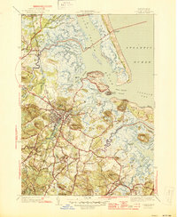
 1952 Newburyport East1954 Print · USGSCoastal Massachusetts and New Hampshire meet at the mouth of the Merrimack River during the early fifties, where maritime commerce and conservation intersect. Researchers can trace ancestral sites at the First Burial Ground or locate vanished landmarks like Butlers Toothpick and Woodbridge Sch.3 unique versions available
 - 1953 Map of Georgetown, 1954 Print
 1953 Georgetown1954 Print · USGSMid-century Essex County is captured here at a time of rural stability and emerging suburban growth. Genealogists and researchers can trace family lands near South Byfield (PO), the historic Dummer Academy, and the Rowley Burial Ground.4 unique versions available
 - 1956 Map of Boston, 1967 Print
 1956 Boston1967 Print · USGSThe Massachusetts coastline and industrial interior are seen here during the mid-century peak of suburban and highway expansion. Researchers can trace historic harbor defenses like Fort Revere, local landmarks such as Faneuil Hall, and the vast Parker River National Wildlife Refuge.6 unique versions available
 - 1958 Map of Boston
 1958 Boston1958 Print · USGSEastern Massachusetts and southern New Hampshire are shown at the height of the industrial era, before the full expansion of the interstate system. Trace coastal defenses at Fort Warren, historic rail lines like the Boston and Maine, and the development of the Mass. 128 corridor.2 unique versions available
 - 1961 Map of Boston
 1961 Boston1961 Print · USGSThe Massachusetts coastline and its industrial interior are detailed here in the mid-twentieth century, from the Monadnock highlands to Cape Cod. Researchers can trace the rail routes of the Boston and Maine or locate landmarks like Fort Devens and the Wachusett Reservoir.2 unique versions available
 - 1966 Map of Ipswich, 1967 Print
 1966 Ipswich1967 Print · USGSThe North Shore coast in the mid-sixties reveals a intricate landscape of salt marshes and historic town centers. Researchers can trace the legacy of family estates and religious institutions at Castle Hill, Locust Grove Cem, and the Sacred Heart Juniorate.3 unique versions available
 - 1966 Map of Newburyport East, 1968 Print
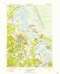
 1966 Newburyport East1968 Print · USGSCoastal Massachusetts and New Hampshire meet at the Merrimack during the mid-sixties, capturing the maritime character of this historic estuary. Genealogists can locate family plots in Oak Hill Cem or the First Parish Burying Ground, while maritime historians can trace the Newburyport Light and U S Coast Guard Station.3 unique versions available
 - 1966 Map of Georgetown, 1968 Print
 1966 Georgetown1968 Print · USGSCoastal Massachusetts at the dawn of the interstate era shows a mix of historical academy grounds and new highway developments. Trace family roots at the Rowley Burial Ground or locate landmarks like the Governor Dummer Academy and Asbury Grove.2 unique versions available
Showing maps 1-25 of 53
Top cities near Newbury
- Haverhill historical maps
- Peabody historical maps
- Salem historical maps
- Beverly historical maps
- Gloucester historical maps
- Danvers historical maps
See more
Top neighborhoods of Newbury
- South Byfield historical maps
- Newbury Old Town historical maps
- Byfield historical maps
- Adams' Town historical maps
- Cedar Hill historical maps
- Parker River Residential District historical maps
See more
Frequently asked questions
- What are the different types of historical maps available for Newbury?
- What is the oldest map of Newbury?
- Where can I purchase historical maps of Newbury for my home or office?
- Where can I download high-res historical maps of Newbury?
- Are there historical topographic maps available for Newbury?
- Is there historical aerial imagery available for Newbury?
- Where are historical maps of Newbury sourced from?