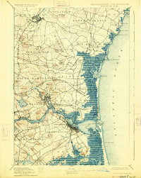
1888 Map of Newburyport
USGS Topo · Published 1888About this map
The Merrimac River carves a deep path through this coastal landscape, serving as a vital industrial and navigational artery during the late 19th and early 20th centuries. Centered on the maritime hub of Newburyport, the map reveals a complex network of island geography including Carr Island and Eagle Id. situated just upstream from the city. The shoreline is defined by the expansive marshes and waterways of the Plum Island River and Hampton Harbor, protected by the Atlantic Ocean surf. Inland, the heavy influence of the Boston and Maine Railroad is evident, with the Eastern Division and the Salisbury Branch connecting manufacturing centers like Amesbury and Exeter to the coast. Prominent family landmarks and terrain features, such as Whittier Hill and Pipestave Hill, dot the landscape between old established settlements like Newbury Old Town and Hampton Falls.
Find a feature on this map
96 named features on this map. Tap any name to fly to it.
Don’t see what you’re looking for? This feature index may not catch every label — zoom into the map to look around manually.
Map Details
Editions of this 1888 Newburyport Map
This is the sole edition of this map. No revisions or reprints were ever made.
Historical Maps of Haverhill Through Time
5 maps found