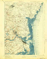
1890 Map of Newburyport
USGS Topo · Published 1890About this map
Newburyport and the Merrimac River dominate this coastal landscape, which depicts the vital maritime and industrial corridor between Massachusetts and New Hampshire in the late nineteenth century. The map shows the intricate network of the Boston and Maine Railroad, including its Salisbury Branch and Newburyport Branch, illustrating the transition from ship-based trade to rail-driven commerce. Small village centers like Amesbury and Exeter are detailed alongside coastal landmarks such as the Newburyport Light and the U.S. Life Saving Station on Plum Island River. The terrain is characterized by a series of drumlins and glacial hills like Powow Hill and Great Boar's Head, while the extensive tidal marshes and harbor entries at Hampton Harbor highlight the shifting geography of the Seacoast region.
Find a feature on this map
106 named features on this map. Tap any name to fly to it.
Don’t see what you’re looking for? This feature index may not catch every label — zoom into the map to look around manually.
Map Details
Editions of this 1890 Newburyport Map
This is the sole edition of this map. No revisions or reprints were ever made.
Historical Maps of Haverhill Through Time
5 maps found