1980s Maps of Rowley, Massachusetts
Explore 5 historic maps of Rowley from the 1980s. These maps offer a rare glimpse into what life looked like during the 1980s — showing old roads, neighborhoods, homes, and landmarks that have changed or disappeared over time.
Whether you're researching your family's past, planning a metal detecting trip, or studying how Rowley's landscape evolved across the 1980s, these high-resolution maps are a powerful tool for exploring the history of this region.
- Focus on a specific era: All maps on this page are from the 1980s, giving you a focused view of this time period.
- See what’s changed: Compare century-old streets, trails, and buildings to today's modern landscape using overlays and satellite layers.
- Research with precision: Use these maps for genealogy, historical research, land use analysis, or educational projects.
- View, download, or print: Maps are fully viewable online in high resolution, and can be downloaded or printed for your own records.
Start exploring Rowley's history through authentic maps from the 1980s. This is your window into the past.
Rowley, MA maps
(5)- 1984 Map of Gloucester
 1984 Gloucester1984 Print · USGSCoastal Massachusetts and the New Hampshire borderlands are shown here in the mid-eighties, from the granite shores of Cape Ann to the Merrimack River. Researchers can trace the legacy of maritime trade and higher education at Salem State College or follow the Boston and Maine rail lines through Ipswich and Beverly.
 - 1984 Map of Rockport
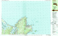 1984 Rockport1984 Print · USGSCape Ann's rugged Atlantic coastline and granite quarrying history are on full display in this mid-eighties record. Genealogists and historians can trace the Boston and Maine railroad line through Rockport and locate family plots at Beech Grove Cem or Locust Grove Cem.2 unique versions available
 - 1985 Map of Newburyport
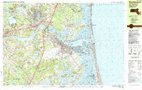 1985 Newburyport1985 Print · USGSCoastal Massachusetts and the New Hampshire border are captured in the mid-1980s as the Merrimack River communities balanced growth with conservation. Researchers can trace the grounds of Governor Dummer Academy, locate the Newburyport Light, and explore historic burial sites like Belleville Cem.
 - 1985 Map of Ipswich, 1986 Print
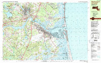
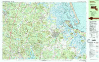 1985 Ipswich1986 Print · USGSThe North Shore of Massachusetts is shown in the mid-eighties as a landscape of ancient coastal towns and protected wetlands. Researchers can trace local heritage at Rowley Burial Ground, explore the grounds of Governor Dummer Academy, or locate the cottages of Asbury Grove.3 unique versions available
 - 1987 Map of Newburyport
 1987 Newburyport1987 Print · USGSCoastal Massachusetts and the New Hampshire border are captured in the late eighties as the Merrimack estuary meets the sea. Genealogists can locate family plots at Sawyer Hill Burying Ground or trace the industrial footprint of the Boston and Maine railroad.2 unique versions available
End of results
Showing maps 1-5 of 5
Top cities near Rowley
- Lynn historical maps
- Haverhill historical maps
- Peabody historical maps
- Salem historical maps
- Beverly historical maps
- Gloucester historical maps
See more
Top neighborhoods of Rowley
- Rooty Plain historical maps
- Doles Corner historical maps
- Glen Mills historical maps
- Leightons Corner historical maps
- Kent Corner historical maps
- Hog Islands historical maps
Frequently asked questions
- What are the different types of historical maps available for Rowley?
- What is the oldest map of Rowley?
- Where can I purchase historical maps of Rowley for my home or office?
- Where can I download high-res historical maps of Rowley?
- Are there historical topographic maps available for Rowley?
- Is there historical aerial imagery available for Rowley?
- Where are historical maps of Rowley sourced from?