1970s Maps of Deerfield, Massachusetts
Explore 6 historic maps of Deerfield from the 1970s. These maps offer a rare glimpse into what life looked like during the 1970s — showing old roads, neighborhoods, homes, and landmarks that have changed or disappeared over time.
Whether you're researching your family's past, planning a metal detecting trip, or studying how Deerfield's landscape evolved across the 1970s, these high-resolution maps are a powerful tool for exploring the history of this region.
- Focus on a specific era: All maps on this page are from the 1970s, giving you a focused view of this time period.
- See what’s changed: Compare century-old streets, trails, and buildings to today's modern landscape using overlays and satellite layers.
- Research with precision: Use these maps for genealogy, historical research, land use analysis, or educational projects.
- View, download, or print: Maps are fully viewable online in high resolution, and can be downloaded or printed for your own records.
Start exploring Deerfield's history through authentic maps from the 1970s. This is your window into the past.
Deerfield, MA maps
(6)- 1971 Map of Mt Toby, 1973 Print
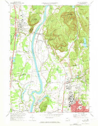 1971 Mt Toby1973 Print · USGSMassachusetts' Pioneer Valley is shown here in the early seventies, centered on the Connecticut River corridor. Genealogists and historians can trace family sites near Wildwood Cemetery, the evolving University of Massachusetts campus, and the industrial relics at Factory Hollow.2 unique versions available
 - 1975 Map of Mt Toby, 1981 Print
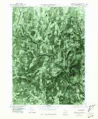
 1975 Mt Toby1981 Print · USGSThe Pioneer Valley mid-century agricultural landscape is frozen in time in this 1970s aerial survey. Genealogists and local historians can trace the field patterns and original footprints of Sunderland, South Deerfield, and Russellville.
 - 1975 Map of Shelburne Falls, 1981 Print
 1975 Shelburne Falls1981 Print · USGSFranklin County's upland farms and river valleys are captured in the mid-seventies, showing the area's transition into the modern era. Trace the landscape around Shelburne Falls, the winding Deerfield River, and the rural crossroads of Shirkshire.
 - 1975 Map of Williamsburg, 1981 Print
 1975 Williamsburg1981 Print · USGSWilliamsburg and the surrounding hill towns appear in high-altitude detail during the mid-seventies. Local historians can trace the building footprints in Williamsburg, find the residential clusters of Searsville, and follow the course of the Mill River.
 - 1975 Map of Greenfield, 1981 Print
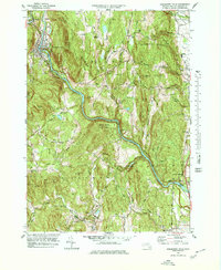
 1975 Greenfield1981 Print · USGSFranklin County's river valleys appear in sharp detail in the mid-1970s, showing the intersection of industrial towns and traditional farmlands. Researchers can trace the development patterns of Greenfield, Turners Falls, and Deerfield alongside the winding Connecticut River.
 - 1978 Map of Shelburne Falls, 1979 Print
 1978 Shelburne Falls1979 Print · USGSWestern Massachusetts hill towns and river valleys are captured here in the late seventies. Family historians can locate numerous rural burial grounds such as Arms Cem and Pine Grove Cem, while tracing the path of the BOSTON AND MAINE RAILROAD.
End of results
Showing maps 1-6 of 6
Top cities near Deerfield
- Amherst historical maps
- Northampton historical maps
- Greenfield historical maps
- South Hadley historical maps
- Belchertown historical maps
- Montague historical maps
See more
Top neighborhoods of Deerfield
- South Deerfield historical maps
- Wapping historical maps
- Mill River historical maps
- East Deerfield historical maps
- West Deerfield historical maps
- Old Deerfield Village Historic District historical maps
Frequently asked questions
- What are the different types of historical maps available for Deerfield?
- What is the oldest map of Deerfield?
- Where can I purchase historical maps of Deerfield for my home or office?
- Where can I download high-res historical maps of Deerfield?
- Are there historical topographic maps available for Deerfield?
- Is there historical aerial imagery available for Deerfield?
- Where are historical maps of Deerfield sourced from?