Old Maps of Montague, Massachusetts for Genealogy
Trace your family roots with 37 historic maps of Montague. These high-res maps reveal old neighborhoods, homesites, landmarks, and streets — helping you uncover where your ancestors lived and how the area evolved over time.
- Explore historic neighborhoods: Identify where your relatives may have lived in the 1800s or 1900s.
- Compare maps over time: Trace the changes in streets, buildings, and landmarks for multi-generational research.
- Perfect for genealogy & ancestry research: Used by family historians and researchers to map out lineage and migration.
These maps are an incredible resource for exploring your personal connection to Montague's past.
Montague, MA maps
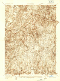
(37)- 1887 Map of Warwick
 1887 Warwick1887 Print · USGSUpper Massachusetts and the New Hampshire border at the close of the nineteenth century reveal a landscape of river-powered industry and rail-connected villages. Researchers can trace the path of the Fitchburg R.R. through Millers Falls or locate early river crossings like Munns Ferry.
 - 1889 Map of Warwick
 1889 Warwick1889 Print · USGSFranklin County in the late 1880s was defined by its busy rail junctions and river valleys. Genealogists and historians can trace the development of Orange and Northfield, or locate vanished rail stops like Gill Station and Wendell Depot along the Fitchburg Railroad.
 - 1890 Map of Greenfield
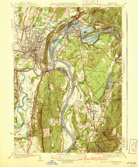
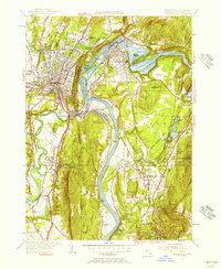
 1890 Greenfield1890 Print · USGSFranklin County's industrial and rail corridors are captured in the late nineteenth century as the river valleys pulsed with water-powered manufacturing. Genealogists and historians can trace the foundations of Turners Falls, the layout of Lake Pleasant Camp Ground, and the rail connections at Conway Depot.
 - 1894 Map of Greenfield
 1894 Greenfield1894 Print · USGSFranklin County's industrial river valleys are captured here in the late 19th century as rail lines and water power drove local growth. Genealogists and historians can trace the foundations of Turner Falls, the transit hub at Cheapside, and the historic village of Deerfield.10 unique versions available
 - 1894 Map of Warwick
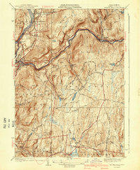
 1894 Warwick1894 Print · USGSNorthern Massachusetts and New Hampshire borderlands are captured here in the late nineteenth century, showing a landscape shaped by the Millers River. Researchers can trace the path of the Central Vermont Railroad and find early settlements like Wendell Depot and Northfield.6 unique versions available
 - 1935 Map of Warwick
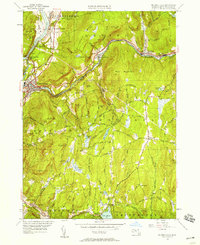
 1935 Warwick1935 Print · USGSUpper Massachusetts and the Tri-State borderlands thrive during the mid-thirties as rail corridors and river valleys connect mountain villages. Researchers can trace the Central Vermont Ry through Northfield or locate family landmarks like Barrows Cem and Barber Sch.2 unique versions available
 - 1936 Map of Greenfield
 1936 Greenfield1936 Print · USGSFranklin County is captured in the mid-1930s as a thriving rail and river hub at the heart of the Pioneer Valley. Genealogists and local historians can trace family roots through the streets of Greenfield, locate the Swedish Cem, or find the C C C Camp No 1226.
 - 1936 Map of Millers Falls
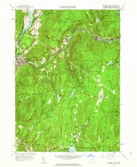
 1936 Millers Falls1936 Print · USGSFranklin County's river valleys and rail corridors are captured here in the mid-1930s. Researchers can locate family homesteads near Northfield Farms Cem, trace the vanished Tyler City, or follow the historic Mohawk Trail.
 - 1941 Map of Greenfield
 1941 Greenfield1941 Print · USGSFranklin County's river-driven industry and academic centers are on full display in this pre-war survey of the Pioneer Valley. Researchers can trace the rail networks and find local landmarks like Deerfield Academy, Lake Pleasant, and the High St Cem.3 unique versions available
 - 1941 Map of Millers Falls
 1941 Millers Falls1941 Print · USGSFranklin County's river valleys and upland hills are captured here in the years before the mid-century expansion. Genealogists can locate family names and rural landmarks such as Locks Village, the Northfield Farms Cem, and the Farley Sch.3 unique versions available
 - 1942 Map of Keene
 1942 Keene1942 Print · USGSCheshire County at the start of the war shows a landscape of busy river valleys and upland farms. You can trace the path of the Boston & Maine RR through towns like Westmoreland and find old district landmarks like Sch No 10 or the Rand Cem.
 - 1943 Map of Brattleboro
 1943 Brattleboro1943 Print · USGSSouthern Vermont and the Massachusetts border area appear in this mid-century survey as a landscape of timbered peaks and river-connected villages. Genealogists can trace family roots through markers like Arms Cem or follow the rails at Dummerston Sta and Putney Sta.
 - 1948 Map of Albany, 1951 Print
 1948 Albany1951 Print · USGSThe Hudson and Connecticut River valleys are captured here in the late 1940s, showing the vital rail and water corridors of the Northeast. You can trace the Boston and Maine tracks past Mt Greylock or locate early settlements like Great Barrington and Bennington.
 - 1948 Map of Millers Falls, 1958 Print
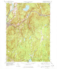
 1948 Millers Falls1958 Print · USGSFranklin County's river valleys and rail junctions are shown here in the late 1940s as the regional economy hummed along the water. Researchers can trace historic family-named cemeteries like Gardner Cem or find the local Northfield Farms Sch and Locks Village Ch.
 - 1954 Map of Greenfield, 1956 Print
 1954 Greenfield1956 Print · USGSThe Connecticut River valley thrives in the mid-1950s as a hub of industry, transport, and education. Researchers can trace the storied campuses of Deerfield Academy and Eagle Brook Sch or locate rail junctions at Montague Sta.2 unique versions available
 - 1956 Map of Albany, 1968 Print
 1956 Albany1968 Print · USGSThe industrial heart of the Northeast is revealed in the mid-1950s, from the Hudson Valley to the Connecticut River. Researchers can trace the legacy of the Quabbin Reservoir, locate Westover Air Force Base, or follow the Rutland RR through the Green Mountains.2 unique versions available
 - 1957 Map of Albany
 1957 Albany1957 Print · USGSThe Tri-State region and Connecticut River Valley are captured here during a period of significant postwar growth and infrastructure expansion. Genealogists and historians can trace the rail-and-river economy through landmarks like the Boston and Maine railroad, Quabbin Reservoir, and Westover Air Force Base.
 - 1959 Map of Albany
 1959 Albany1959 Print · USGSThe Hudson and Connecticut River valleys are captured here during the late fifties, showing the region's dense rail networks and massive water projects. Researchers can trace the New York State Thruway or locate local landmarks like Mt Greylock and the Quabbin Reservoir.
 - 1961 Map of Millers Falls, 1963 Print
 1961 Millers Falls1963 Print · USGSFranklin County's river-driven industrial hubs and forested uplands are documented here in the early sixties. Researchers can trace the rail junction at Millers Falls, find remote burial sites like Dry Hill Cem, and explore the shoreline of Lake Wyola.2 unique versions available
 - 1962 Map of Albany
 1962 Albany1962 Print · USGSThe Hudson and Connecticut River valleys meet the Green Mountains and Berkshires in this mid-century overview of the Northeast. Genealogists and historians can trace the industrial hearts of Albany and Springfield or locate features like Quabbin Reservoir and Westover Air Force Base.
 - 1968 Map of Greenfield, 1979 Print
 1968 Greenfield1979 Print · USGSThe industrial and academic heart of the Connecticut River Valley is captured here in the late sixties. Genealogists and historians can trace the campuses of Deerfield Academy and Eagle Brook School, along with the rail yards at East Deerfield and the historic Poets Seat.
 - 1975 Map of Millers Falls, 1981 Print
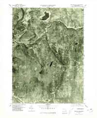 1975 Millers Falls1981 Print · USGSFranklin County in the mid-seventies is captured here through detailed aerial imagery showing the river-valley settlements of the Connecticut and Millers rivers. Researchers can trace the layout of villages like Millers Falls, Farley, and Locks Village.
 - 1975 Map of Greenfield, 1981 Print
 1975 Greenfield1981 Print · USGSFranklin County's river valleys appear in sharp detail in the mid-1970s, showing the intersection of industrial towns and traditional farmlands. Researchers can trace the development patterns of Greenfield, Turners Falls, and Deerfield alongside the winding Connecticut River.
 - 1977 Map of Millers Falls
 1977 Millers Falls1977 Print · USGSFranklin County's rail-and-river network is on full display in the 1970s, from the industrial confluence at Millers Falls to the heights of Northfield Mountain Reservoir. Genealogists and hikers can trace old routes to Field Cem, the community at Northfield Farms, and landmarks like Monks Cave.2 unique versions available
 - 1986 Map of Keene
 1986 Keene1986 Print · USGSThe tri-state borderlands of the Connecticut River Valley come alive in this mid-eighties survey of southern Vermont, New Hampshire, and Massachusetts. Genealogists and historians can trace rail-era villages like Ashuelot and Millers Falls alongside landmarks like Marlboro College and Monadnock Mountain.3 unique versions available
Showing maps 1-25 of 37
Top cities near Montague
- Amherst historical maps
- Northampton historical maps
- Greenfield historical maps
- Belchertown historical maps
- Ware historical maps
- Orange historical maps
See more
Top neighborhoods of Montague
- Grounts Corner historical maps
- Montague City historical maps
- Montague Station historical maps
- Turners Falls historical maps
- Lake Pleasant historical maps
- Millers Falls historical maps
See more
Frequently asked questions
- What are the different types of historical maps available for Montague?
- What is the oldest map of Montague?
- Where can I purchase historical maps of Montague for my home or office?
- Where can I download high-res historical maps of Montague?
- Are there historical topographic maps available for Montague?
- Is there historical aerial imagery available for Montague?
- Where are historical maps of Montague sourced from?