1930s Maps of The Commons, Chicopee
Explore 2 historic maps of The Commons from the 1930s. These maps offer a rare glimpse into what life looked like during the 1930s — showing old roads, neighborhoods, homes, and landmarks that have changed or disappeared over time.
Whether you're researching your family's past, planning a metal detecting trip, or studying how The Commons's landscape evolved across the 1930s, these high-resolution maps are a powerful tool for exploring the history of this region.
- Focus on a specific era: All maps on this page are from the 1930s, giving you a focused view of this time period.
- See what’s changed: Compare century-old streets, trails, and buildings to today's modern landscape using overlays and satellite layers.
- Research with precision: Use these maps for genealogy, historical research, land use analysis, or educational projects.
- View, download, or print: Maps are fully viewable online in high resolution, and can be downloaded or printed for your own records.
Start exploring The Commons's history through authentic maps from the 1930s. This is your window into the past.
The Commons, Chicopee maps
(2)- 1933 Map of Chicopee
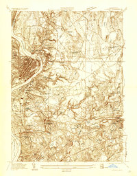 1933 Chicopee1933 Print · USGSThe industrial corridor of the Pioneer Valley is frozen in time during the early 1930s, showing the dense mill and residential centers along the river bends. Trace local family history through numerous landmarks like St Patrick Cem, the West Street Sch, and the grounds of the Springfield Airport.
 - 1938 Map of Springfield North
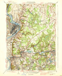 1938 Springfield North1938 Print · USGSThe industrial corridor of the Connecticut River comes alive in this pre-war survey, showcasing the canal-driven growth of Holyoke and Chicopee. Genealogists can trace family roots through sites like St Stanislaus Cem or the localized neighborhoods of Aldenville and South Hadley Falls.4 unique versions available
End of results
Showing maps 1-2 of 2
Frequently asked questions
- What are the different types of historical maps available for The Commons?
- What is the oldest map of The Commons?
- Where can I purchase historical maps of The Commons for my home or office?
- Where can I download high-res historical maps of The Commons?
- Are there historical topographic maps available for The Commons?
- Is there historical aerial imagery available for The Commons?
- Where are historical maps of The Commons sourced from?