1933 Map of Chicopee
USGS Topo · Published 1933About this map
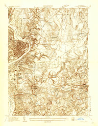
Industrial and residential development along the Chicopee River defines this 1930s landscape, where the water's path curves through the heart of Chicopee Falls and Indian Orchard. The Connecticut River forms the western boundary, with the concentrated urban grid of Chicopee and South Hadley Falls contrasting against the more open terrain of Fairview and Aldenville. The presence of the Massachusetts Nat Guard Rifle Range and the Springfield Airport suggests the growing tactical and transportation infrastructure of the era. Public health and social services of the day are clearly marked by the Chicopee Tuberculosis Hospital and the Chicopee Infirmary. Genealogists will find several large burial grounds, including St Stanislaus Cem and Calvary Cem, which reflect the community's established ethnic and religious neighborhoods.
Find a feature on this map
64 named features on this map. Tap any name to fly to it.
Don’t see what you’re looking for? This feature index may not catch every label — zoom into the map to look around manually.
Map Details
Editions of this 1933 Chicopee Map
This is the sole edition of this map. No revisions or reprints were ever made.
Historical Maps of Springfield Through Time
1 maps found