1940s Maps of Hampshire County, Massachusetts
Explore 43 historic maps of Hampshire County from the 1940s. These maps offer a rare glimpse into what life looked like during the 1940s — showing old roads, neighborhoods, homes, and landmarks that have changed or disappeared over time.
Whether you're researching your family's past, planning a metal detecting trip, or studying how Hampshire County's landscape evolved across the 1940s, these high-resolution maps are a powerful tool for exploring the history of this region.
- Focus on a specific era: All maps on this page are from the 1940s, giving you a focused view of this time period.
- See what’s changed: Compare century-old streets, trails, and buildings to today's modern landscape using overlays and satellite layers.
- Research with precision: Use these maps for genealogy, historical research, land use analysis, or educational projects.
- View, download, or print: Maps are fully viewable online in high resolution, and can be downloaded or printed for your own records.
Start exploring Hampshire County's history through authentic maps from the 1940s. This is your window into the past.
Hampshire County, MA maps
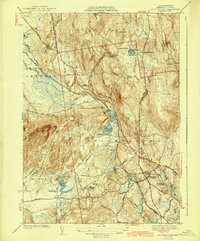
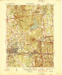
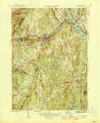
(43)- 1941 Map of Mt Holyoke
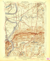 1941 Mt Holyoke1941 Print · USGSHampshire County thrives along the Connecticut River in the years before the Second World War. Researchers can trace the early footprints of Amherst College, locate family sites at Smiths Ferry, or find small rural centers like Moody Corner and Aldrich Mills.3 unique versions available
 - 1941 Map of Mt Toby
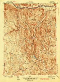
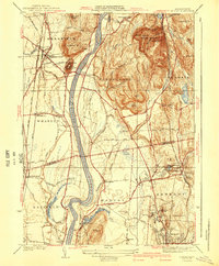 1941 Mt Toby1941 Print · USGSThe Pioneer Valley in the mid-thirties was a vital corridor for three major rail lines and a center for higher education. Genealogists can trace family names and landmarks across Sunderland and Amherst, including Massachusetts State College and the East Whately Cem.3 unique versions available
 - 1941 Map of Williamsburg
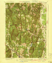 1941 Williamsburg1941 Print · USGSFranklin and Hampshire counties appear in the early 1940s, showing the intersection of industrial rail towns and upland forests. Researchers can trace the rail line to the Williamsburg Sta or find family landmarks like Petticoat Hill and West Whately.3 unique versions available
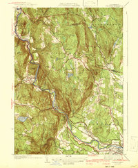
 - 1942 Map of Ludlow
 1942 Ludlow1942 Print · USGSHampden County landscapes in the late thirties reveal a mix of industrial river towns and upland reservoirs. Genealogists can trace family footprints through the Wilbraham Academy, East Wilbraham Cem, and the neighborhoods around Indian Orchard.
 - 1942 Map of Ware
 1942 Ware1942 Print · USGSCentral Massachusetts and the Connecticut border are captured here during the early years of the war, just as the landscape was being reshaped by the Quabbin Reservoir. Researchers can trace rail-era industry and local landmarks like the Lead Mine and the Bald Peak Hospital.
 - 1942 Map of Woronoco
 1942 Woronoco1942 Print · USGSThe Berkshires meet industrial river valleys in the early 1940s, where the railroad and river define local life. Trace historic marble extraction at the Marble Quarries or find family roots at Clarks Cem and settlements like Woronoco Heights.2 unique versions available
 - 1942 Map of Shutesbury
 1942 Shutesbury1942 Print · USGSThe western edge of the newly formed Quabbin Reservoir meets the wooded uplands of Franklin County in the early 1940s. Local researchers can trace family homesteads and rural crossroads near Shutesbury, East Leverett, and the Rhodes Sch at a time when mountain agriculture still shaped the land.
 - 1942 Map of Belchertown
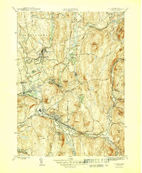
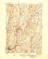
 1942 Belchertown1942 Print · USGSHampshire County at the start of the 1940s reveals a landscape of rural crossroads and growing state institutions. Genealogists and historians can trace family-named landmarks like Cooks Corner and Meads Corner or locate the sprawling State School grounds.
 - 1943 Map of Belchertown
 1943 Belchertown1943 Print · USGSHampshire County at the onset of the 1940s reveals a landscape where rail lines and rural schools defined the community. Genealogists and historians can trace family roots at Dwight Cem or locate institutional landmarks like St Hyacinths Seminary and the State School.4 unique versions available
 - 1943 Map of Shutesbury
 1943 Shutesbury1943 Print · USGSFranklin and Hampshire counties appear here during the early 1940s as the eastern landscape adjusted to the presence of the Quabbin Reservoir. Local historians can trace family locations near Shutesbury and Pelham, locating landmarks like Rhodes Sch and West Cem.4 unique versions available
 - 1943 Map of Brookfield
 1943 Brookfield1943 Print · USGSCentral Massachusetts at the height of the war era shows a landscape of busy rail towns and upland ponds. Genealogists and historians can trace family-named peaks like Coys Hill and old industry along the Boston and Albany RR or near Southbridge.
 - 1943 Map of Holyoke
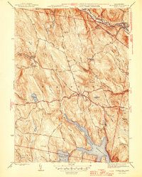
 1943 Holyoke1943 Print · USGSThe Pioneer Valley and the eastern Berkshires are captured here in the early 1940s, showing a robust network of river-side industry and hill-country forests. Researchers can locate vanished landmarks and institutional grounds like Northampton State Hospital, Barnes Airport, and the Nat Gd Rifle Range.
 - 1943 Map of Brattleboro
 1943 Brattleboro1943 Print · USGSSouthern Vermont and the Massachusetts border area appear in this mid-century survey as a landscape of timbered peaks and river-connected villages. Genealogists can trace family roots through markers like Arms Cem or follow the rails at Dummerston Sta and Putney Sta.
 - 1943 Map of Ashfield
 1943 Ashfield1943 Print · USGSFranklin County hill towns and the river valley are captured here just before the mid-century, showing a landscape of small hamlets and high ridges. Trace old family plots at Leavitt Cem or follow the historic Mohawk Trail and Ashfield Pond.2 unique versions available
 - 1943 Map of Housatonic
 1943 Housatonic1943 Print · USGSThe Berkshires and the Housatonic Valley are captured during the war years, showing a landscape of traditional Shaker settlements and growing industrial centers. Trace the routes of the NY NH & H RR and explore sites like Shaker Village, Richmond Furnace, and Rockdale Mills.
 - 1944 Map of Winsor Dam
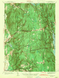
 1944 Winsor Dam1944 Print · USGSIn the early 1940s, the Swift River Valley was recently transformed into a critical water resource for Massachusetts. Local historians can trace the new shoreline and legacy sites like the Quabbin Park Cem, Winsor Dam, and the hilltop Lookout on Quabbin Hill.3 unique versions available
 - 1944 Map of Ludlow
 1944 Ludlow1944 Print · USGSHampden County’s industrial river valley and rolling hills are captured here just after the war. Researchers can trace historic family connections through Wilbraham Academy, Hillcrest Park Cem, and the rail lines serving North Wilbraham.3 unique versions available
 - 1944 Map of Quabbin Reservoir
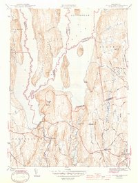
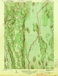 1944 Quabbin Reservoir1944 Print · USGSCentral Massachusetts undergoes a total transformation in the early forties as the valley fills to create a massive water system. Trace former upland settlements like North Prescott and prominent landmarks like Soapstone Hill and the Baffle Dam.3 unique versions available
 - 1944 Map of Mt Toby, 1954 Print
 1944 Mt Toby1954 Print · USGSThe Pioneer Valley in the mid-forties shows a landscape defined by the Connecticut River and its railroads. Genealogists can trace family names through Wildwood Cemetery or North Sunderland Cem and locate schools like Three Corners Sch.2 unique versions available
 - 1945 Map of Peru, 1958 Print
 1945 Peru1958 Print · USGSIn the Berkshire Highlands at the end of the Second World War, this landscape shows the quiet character of rural Massachusetts hill towns. Genealogists and hikers can trace the original paths of Buttermilk Road, the remote Peru Cem, and the historic transit line of the Boston and Albany RR.
 - 1945 Map of Becket, 1958 Print
 1945 Becket1958 Print · USGSThe Berkshire highlands come alive in this post-war study of the river-and-rail corridor. Genealogists and historians can trace the path of the Boston & Albany RR through settlements like Bancroft or locate family sites near Becket Center and the Washington Cem.
 - 1946 Map of Blandford
 1946 Blandford1946 Print · USGSBlandford and Huntington are captured here in the mid-1940s, a period defined by the expansion of reservoirs and old mountain turnpikes. Researchers can trace the General Knox Trail, locate the North Blandford Cem, and study the industrial rail lines of the Boston and Albany RR.2 unique versions available
 - 1946 Map of Palmer
 1946 Palmer1946 Print · USGSHampden County in the mid-1940s is defined by a dense network of river-driven industrial villages and major rail junctions. Researchers can trace the busy corridors of the Boston and Albany RR through the village of Three Rivers or locate the State Fish Hatchery and Landing Field.4 unique versions available
 - 1946 Map of Warren
 1946 Warren1946 Print · USGSMid-century Worcester County comes to life along the Quaboag River valley just after the war. Local historians can trace the industrial corridor of the Boston and Albany RR through West Warren and locate landmarks like St Marys Cem or Schoolhouse No 4.3 unique versions available
 - 1946 Map of Ware
 1946 Ware1946 Print · USGSCentral Massachusetts was a landscape of river-powered industry and upland farms in the years following the war. Genealogists and historians can trace rail-to-river connections through Gilbertville, locate rural landmarks like School No 2, and explore the terrain around Wickaboag Pond.2 unique versions available
Showing maps 1-25 of 43
Top cities of Hampshire County
- Amherst historical maps
- Northampton historical maps
- South Hadley historical maps
- Easthampton historical maps
- Belchertown historical maps
- Ware historical maps
See more
Frequently asked questions
- What are the different types of historical maps available for Hampshire County?
- What is the oldest map of Hampshire County?
- Where can I purchase historical maps of Hampshire County for my home or office?
- Where can I download high-res historical maps of Hampshire County?
- Are there historical topographic maps available for Hampshire County?
- Is there historical aerial imagery available for Hampshire County?
- Where are historical maps of Hampshire County sourced from?