1970s Maps of Hampshire County, Massachusetts
Explore 35 historic maps of Hampshire County from the 1970s. These maps offer a rare glimpse into what life looked like during the 1970s — showing old roads, neighborhoods, homes, and landmarks that have changed or disappeared over time.
Whether you're researching your family's past, planning a metal detecting trip, or studying how Hampshire County's landscape evolved across the 1970s, these high-resolution maps are a powerful tool for exploring the history of this region.
- Focus on a specific era: All maps on this page are from the 1970s, giving you a focused view of this time period.
- See what’s changed: Compare century-old streets, trails, and buildings to today's modern landscape using overlays and satellite layers.
- Research with precision: Use these maps for genealogy, historical research, land use analysis, or educational projects.
- View, download, or print: Maps are fully viewable online in high resolution, and can be downloaded or printed for your own records.
Start exploring Hampshire County's history through authentic maps from the 1970s. This is your window into the past.
Hampshire County, MA maps
(35)- 1971 Map of Mt Toby, 1973 Print
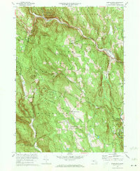
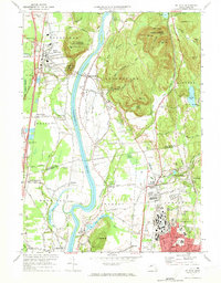 1971 Mt Toby1973 Print · USGSMassachusetts' Pioneer Valley is shown here in the early seventies, centered on the Connecticut River corridor. Genealogists and historians can trace family sites near Wildwood Cemetery, the evolving University of Massachusetts campus, and the industrial relics at Factory Hollow.2 unique versions available
 - 1971 Map of Ashfield, 1973 Print
 1971 Ashfield1973 Print · USGSFranklin County's hill towns and river valleys are shown here in the early 1970s as agricultural life and modern infrastructure intersected. Researchers can trace family sites at Sanderson Academy and the Ashfield Plain Cem or follow the old Boston and Maine rail line.3 unique versions available
 - 1971 Map of Plainfield, 1973 Print
 1971 Plainfield1973 Print · USGSThe Massachusetts highlands of the early 1970s reveal a landscape of dense state forests and quiet upland hamlets. Genealogists and hikers can trace old family burial grounds like Hilltop Cem or explore landmarks such as Windsor Jambs and Plainfield Pond.2 unique versions available
 - 1972 Map of Westhampton, 1973 Print
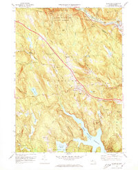
 1972 Westhampton1973 Print · USGSHampshire County highland life and river management are preserved here in the early 1970s. Local researchers can trace family roots through Torrey Cem and Norwich Bridge Cem or locate former industrial sites like Bisbee Mill.2 unique versions available
 - 1972 Map of Worthington, 1973 Print
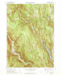
 1972 Worthington1973 Print · USGSThe Berkshires of Hampshire County remained a landscape of quiet hill towns and river valleys in the early seventies. Genealogists can trace family lines through the Bryant Homestead, the Starkweather Hill Sch, and several rural burial grounds like Dawes Cem.2 unique versions available
 - 1972 Map of Goshen, 1973 Print
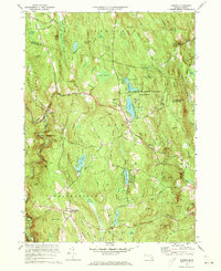 1972 Goshen1973 Print · USGSGoshen and its surrounding highlands appear here in the early 1970s, showcasing a landscape of state forests and summer camps. Genealogists can trace family landmarks like Goshen Cem, Davenport Sch, and the remote Devils Den.4 unique versions available
 - 1972 Map of Blandford, 1973 Print
 1972 Blandford1973 Print · USGSHampden County's upland terrain is captured here in the early seventies as the interstate system and state forests reshaped the Berkshires. Genealogists and historians can locate the North Blandford Cem, trace the Penn Central tracks, and follow the historic Otis General Knox Road.2 unique versions available
 - 1972 Map of Chester, 1973 Print
 1972 Chester1973 Print · USGSThe Massachusetts highlands in the early seventies reveal a landscape of conservation forests and river valleys. Trace old family plots at Old Leonard Cem and follow the rail lines of the Penn Central through Chester and North Chester.2 unique versions available
 - 1972 Map of Springfield North, 1974 Print
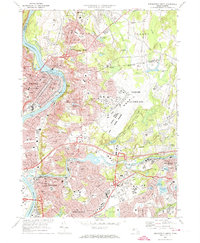 1972 Springfield North1974 Print · USGSGreater Springfield and the Pioneer Valley come into focus in the early 1970s, showing the intersection of river-powered industry and mid-century military growth. Researchers can trace historic cemeteries like Notre Dame Cemetery, local schools, and the massive footprint of Westover Air Force Base.3 unique versions available
 - 1972 Map of Mount Tom, 1974 Print
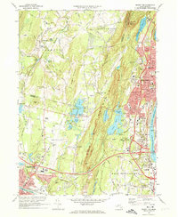 1972 Mount Tom1974 Print · USGSThe industrial corridor of the Connecticut River and the rugged peaks of the Mount Tom Range are captured here in the early 1970s. Trace local history through landmarks like the Dominican Monastery, Barnes Municipal Airport, and the vanished Drive-in Theater near the Hampton Ponds.3 unique versions available
 - 1973 Map of Becket, 1974 Print
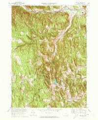
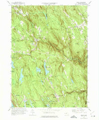 1973 Becket1974 Print · USGSThe Berkshire highlands in the early seventies show a blend of historic hill towns and established cultural landmarks like Jacobs Pillow. Genealogists and historians can trace family-named sites from Bonny Rigg Corners to the Washington Church and Middlefield center.2 unique versions available
 - 1973 Map of Peru, 1975 Print
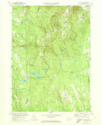
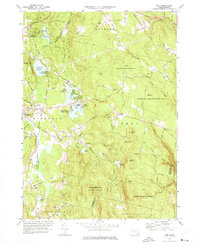 1973 Peru1975 Print · USGSThe Berkshire highlands in the early seventies reveal a landscape of summer camps and state forests. Genealogists can locate family plots at South Cem or Perry Cem, while historians can trace the Penn Central line and the shores of Ashmere Lake.3 unique versions available
 - 1975 Map of Blandford, 1981 Print
 1975 Blandford1981 Print · USGSThe hill towns of Hampden County are captured in the mid-seventies just as the landscape matured around its major water works. Genealogists and local historians can trace the rural layouts of Blandford and North Blandford or locate the shoreline of Cobble Mountain Reservoir.
 - 1975 Map of Peru, 1981 Print
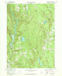
 1975 Peru1981 Print · USGSThe Berkshires of western Massachusetts are captured in the mid-seventies in this detailed orthophoto survey. Local researchers can trace the rural road networks and lakeside developments around Ashmere Lake, Hinsdale, and the town center of Peru.
 - 1975 Map of Mount Tom, 1981 Print
 1975 Mount Tom1981 Print · USGSThe Pioneer Valley in the mid-seventies is captured here via detailed aerial orthophotography. Researchers can trace the industrial layout of Holyoke by the Connecticut River or find local landmarks like Hampton Ponds and Mount Tom.
 - 1975 Map of Palmer, 1981 Print
 1975 Palmer1981 Print · USGSThe confluence of the Quaboag and Ware rivers defines this mid-seventies look at the industrial corridor from Thorndike to Three Rivers. Researchers can trace the layout of traditional mill villages like Bondsville and the more remote West Brimfield.
 - 1975 Map of Ware, 1981 Print
 1975 Ware1981 Print · USGSCentral Massachusetts in the mid-seventies reveals a landscape of river-valley industry and upland farms. Trace the development along the Ware River through Gilbertville and Wheelwright or explore the rural heights of Ragged Hill.
 - 1975 Map of Warren, 1981 Print
 1975 Warren1981 Print · USGSMid-state Massachusetts town life and river geography are captured here in the mid-1970s just as the modern highway system cut through the landscape. Genealogists and local historians can trace property boundaries and industrial footprints in Warren and West Warren, or locate landmarks like Steerage Rock.
 - 1975 Map of Ludlow, 1981 Print
 1975 Ludlow1981 Print · USGSHampden County's industrial and natural landscape is visible in this mid-seventies aerial survey. Trace the river-side growth of Ludlow and North Wilbraham or locate land tracts near Springfield Reservoir and Minechoag Mountain.
 - 1975 Map of Woronoco, 1981 Print
 1975 Woronoco1981 Print · USGSHampden County's river valleys and upland forests are captured in detail in the mid-seventies, showing the intersection of water resources and industry. Trace the historic footprints of Woronoco and Russell along the Westfield River or locate the sprawling Tighe Carmody Reservoir.
 - 1975 Map of Winsor Dam, 1981 Print
 1975 Winsor Dam1981 Print · USGSThe Quabbin Reservoir region in the mid-seventies shows a landscape defined by the balance of engineering and nature. Trace the southern shoreline from Winsor Dam down to the settlements of West Ware and Ware along the Swift River.
 - 1975 Map of Mt Toby, 1981 Print
 1975 Mt Toby1981 Print · USGSThe Pioneer Valley mid-century agricultural landscape is frozen in time in this 1970s aerial survey. Genealogists and local historians can trace the field patterns and original footprints of Sunderland, South Deerfield, and Russellville.
 - 1975 Map of Springfield North, 1981 Print
 1975 Springfield North1981 Print · USGSMassachusetts’ Pioneer Valley appears in striking aerial detail during the mid-seventies, showing the industrial density of the Connecticut River towns. Trace the historic streetscapes of Holyoke and Chicopee or the rural-suburban edges of Scott Corners.
 - 1975 Map of Westhampton, 1981 Print
 1975 Westhampton1981 Print · USGSHampshire County’s wooded hills and river valleys are captured in mid-1970s aerial detail. Researchers can trace land use around Westhampton and follow the paths of the Westfield River or Pine Island Lake.
 - 1975 Map of Easthampton, 1981 Print
 1975 Easthampton1981 Print · USGSNorthampton and the central Pioneer Valley are documented here in the mid-seventies through detailed aerial photography. Genealogists and local historians can trace the exact 1975 footprints of settlements like Loudville, West Farms, and Easthampton.
Showing maps 1-25 of 35
Top cities of Hampshire County
- Amherst historical maps
- Northampton historical maps
- South Hadley historical maps
- Easthampton historical maps
- Belchertown historical maps
- Ware historical maps
See more
Frequently asked questions
- What are the different types of historical maps available for Hampshire County?
- What is the oldest map of Hampshire County?
- Where can I purchase historical maps of Hampshire County for my home or office?
- Where can I download high-res historical maps of Hampshire County?
- Are there historical topographic maps available for Hampshire County?
- Is there historical aerial imagery available for Hampshire County?
- Where are historical maps of Hampshire County sourced from?