1990s Maps of Amherst, Massachusetts
Explore 2 historic maps of Amherst from the 1990s. These maps offer a rare glimpse into what life looked like during the 1990s — showing old roads, neighborhoods, homes, and landmarks that have changed or disappeared over time.
Whether you're researching your family's past, planning a metal detecting trip, or studying how Amherst's landscape evolved across the 1990s, these high-resolution maps are a powerful tool for exploring the history of this region.
- Focus on a specific era: All maps on this page are from the 1990s, giving you a focused view of this time period.
- See what’s changed: Compare century-old streets, trails, and buildings to today's modern landscape using overlays and satellite layers.
- Research with precision: Use these maps for genealogy, historical research, land use analysis, or educational projects.
- View, download, or print: Maps are fully viewable online in high resolution, and can be downloaded or printed for your own records.
Start exploring Amherst's history through authentic maps from the 1990s. This is your window into the past.
Amherst, MA maps
(2)- 1990 Map of Shutesbury
 1990 Shutesbury1990 Print · USGSFranklin County's landscape appears here in the final decade of the century, shaped by the massive waters of the Quabbin Reservoir. Genealogists and local historians can trace the remnants of displaced communities like Prescott Center and locate rural landmarks such as Fairview Cem and Locks Village.2 unique versions available
 - 1990 Map of Williamsburg
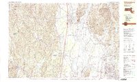 1990 Williamsburg1990 Print · USGSIn the Pioneer Valley during the late twentieth century, the landscape transitioned from the rural hills of Williamsburg to the growing University of Massachusetts campus. Genealogists can trace family names at Whately Center Cem or Riverside Cem and find industrial landmarks like Factory Hollow.2 unique versions available
End of results
Showing maps 1-2 of 2
Top cities near Amherst
- Springfield historical maps
- Chicopee historical maps
- Westfield historical maps
- Holyoke historical maps
- Northampton historical maps
- West Springfield historical maps
See more
Top neighborhoods of Amherst
- Factory Hollow historical maps
- Cushman historical maps
- North Amherst historical maps
- Amherst Woods historical maps
- South Amherst historical maps
- Mill Valley historical maps
See more
Frequently asked questions
- What are the different types of historical maps available for Amherst?
- What is the oldest map of Amherst?
- Where can I purchase historical maps of Amherst for my home or office?
- Where can I download high-res historical maps of Amherst?
- Are there historical topographic maps available for Amherst?
- Is there historical aerial imagery available for Amherst?
- Where are historical maps of Amherst sourced from?