1960s Maps of Belchertown, Massachusetts
Explore 5 historic maps of Belchertown from the 1960s. These maps offer a rare glimpse into what life looked like during the 1960s — showing old roads, neighborhoods, homes, and landmarks that have changed or disappeared over time.
Whether you're researching your family's past, planning a metal detecting trip, or studying how Belchertown's landscape evolved across the 1960s, these high-resolution maps are a powerful tool for exploring the history of this region.
- Focus on a specific era: All maps on this page are from the 1960s, giving you a focused view of this time period.
- See what’s changed: Compare century-old streets, trails, and buildings to today's modern landscape using overlays and satellite layers.
- Research with precision: Use these maps for genealogy, historical research, land use analysis, or educational projects.
- View, download, or print: Maps are fully viewable online in high resolution, and can be downloaded or printed for your own records.
Start exploring Belchertown's history through authentic maps from the 1960s. This is your window into the past.
Belchertown, MA maps
(5)- 1962 Map of Albany
 1962 Albany1962 Print · USGSThe Hudson and Connecticut River valleys meet the Green Mountains and Berkshires in this mid-century overview of the Northeast. Genealogists and historians can trace the industrial hearts of Albany and Springfield or locate features like Quabbin Reservoir and Westover Air Force Base.
 - 1964 Map of Belchertown, 1966 Print
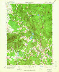 1964 Belchertown1966 Print · USGSHampshire County in the mid-sixties reveals a landscape of wooded ridges and established institutions before later development. Researchers can trace the Central Vermont rail line and locate landmarks like the Belchertown State School or Munsell Cem.3 unique versions available
 - 1967 Map of Winsor Dam, 1969 Print
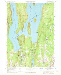 1967 Winsor Dam1969 Print · USGSThe southern reaches of the Quabbin Reservoir are documented here in the late sixties, highlighting the massive water infrastructure of the Swift River Valley. Trace the locations of Winsor Dam, West Ware, and the Quabbin Park Cemetery.3 unique versions available
 - 1969 Map of Ludlow, 1972 Print
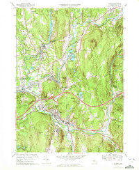
 1969 Ludlow1972 Print · USGSHampden County's river-and-rail corridor is captured here in the late sixties as suburban growth expanded around the historic mill towns. Researchers can trace family sites at the Ludlow Center Cem, follow the Penn Central tracks, or locate mid-century landmarks like the Drive-in Theater.4 unique versions available
 - 1969 Map of Palmer, 1972 Print
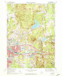
 1969 Palmer1972 Print · USGSThe industrial river valleys of central Massachusetts come to life in this map from the late sixties. Trace the dense rail corridors of the Central Vermont Railroad and find local landmarks like St Anns Cem, the Drive-in Theater, and Wing Memorial Hospital.3 unique versions available
End of results
Showing maps 1-5 of 5
Top cities near Belchertown
- Springfield historical maps
- Chicopee historical maps
- Holyoke historical maps
- Amherst historical maps
- Northampton historical maps
- Agawam historical maps
See more
Top neighborhoods of Belchertown
- Bardwell historical maps
- Meads Corner historical maps
- South Quabbin Villa historical maps
- Dwight historical maps
- Cold Spring historical maps
- Pine Valley Plantation historical maps
See more
Frequently asked questions
- What are the different types of historical maps available for Belchertown?
- What is the oldest map of Belchertown?
- Where can I purchase historical maps of Belchertown for my home or office?
- Where can I download high-res historical maps of Belchertown?
- Are there historical topographic maps available for Belchertown?
- Is there historical aerial imagery available for Belchertown?
- Where are historical maps of Belchertown sourced from?