1970s Maps of Middlefield, Massachusetts
Explore 8 historic maps of Middlefield from the 1970s. These maps offer a rare glimpse into what life looked like during the 1970s — showing old roads, neighborhoods, homes, and landmarks that have changed or disappeared over time.
Whether you're researching your family's past, planning a metal detecting trip, or studying how Middlefield's landscape evolved across the 1970s, these high-resolution maps are a powerful tool for exploring the history of this region.
- Focus on a specific era: All maps on this page are from the 1970s, giving you a focused view of this time period.
- See what’s changed: Compare century-old streets, trails, and buildings to today's modern landscape using overlays and satellite layers.
- Research with precision: Use these maps for genealogy, historical research, land use analysis, or educational projects.
- View, download, or print: Maps are fully viewable online in high resolution, and can be downloaded or printed for your own records.
Start exploring Middlefield's history through authentic maps from the 1970s. This is your window into the past.
Middlefield, MA maps
(8)- 1972 Map of Worthington, 1973 Print
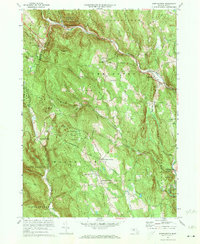 1972 Worthington1973 Print · USGSThe Berkshires of Hampshire County remained a landscape of quiet hill towns and river valleys in the early seventies. Genealogists can trace family lines through the Bryant Homestead, the Starkweather Hill Sch, and several rural burial grounds like Dawes Cem.2 unique versions available
 - 1972 Map of Chester, 1973 Print
 1972 Chester1973 Print · USGSThe Massachusetts highlands in the early seventies reveal a landscape of conservation forests and river valleys. Trace old family plots at Old Leonard Cem and follow the rail lines of the Penn Central through Chester and North Chester.2 unique versions available
 - 1973 Map of Becket, 1974 Print
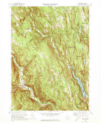
 1973 Becket1974 Print · USGSThe Berkshire highlands in the early seventies show a blend of historic hill towns and established cultural landmarks like Jacobs Pillow. Genealogists and historians can trace family-named sites from Bonny Rigg Corners to the Washington Church and Middlefield center.2 unique versions available
 - 1973 Map of Peru, 1975 Print
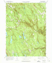
 1973 Peru1975 Print · USGSThe Berkshire highlands in the early seventies reveal a landscape of summer camps and state forests. Genealogists can locate family plots at South Cem or Perry Cem, while historians can trace the Penn Central line and the shores of Ashmere Lake.3 unique versions available
 - 1975 Map of Peru, 1981 Print
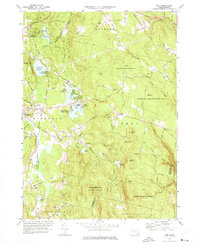
 1975 Peru1981 Print · USGSThe Berkshires of western Massachusetts are captured in the mid-seventies in this detailed orthophoto survey. Local researchers can trace the rural road networks and lakeside developments around Ashmere Lake, Hinsdale, and the town center of Peru.
 - 1975 Map of Becket, 1981 Print
 1975 Becket1981 Print · USGSThe Berkshire highlands are seen in the mid-1970s through this aerial perspective of the Westfield River valley. Genealogists and local historians can trace the rural layouts of Becket, Washington, and the crossroads at Bonny Rigg Corners.
 - 1975 Map of Chester, 1981 Print
 1975 Chester1981 Print · USGSHampden County's hills and river valleys are captured in the mid-1970s as the landscape adapted to modern flood control and forest regrowth. Genealogists and local historians can trace the footprints of Chester, the rural layout of Ringville, and the waters of Littleville Lake.
 - 1975 Map of Worthington, 1981 Print
 1975 Worthington1981 Print · USGSHampshire County enters the mid-seventies as a landscape of river valleys and rural crossroads captured via aerial photography. Genealogists and local historians can trace the exact 1975 footprints of Cummington, West Worthington, and Bryant Four Corners.
End of results
Showing maps 1-8 of 8
Top cities near Middlefield
- Pittsfield historical maps
- Westfield historical maps
- Dalton historical maps
- Southampton historical maps
- Lee historical maps
- Lenox historical maps
See more
Top neighborhoods of Middlefield
Frequently asked questions
- What are the different types of historical maps available for Middlefield?
- What is the oldest map of Middlefield?
- Where can I purchase historical maps of Middlefield for my home or office?
- Where can I download high-res historical maps of Middlefield?
- Are there historical topographic maps available for Middlefield?
- Is there historical aerial imagery available for Middlefield?
- Where are historical maps of Middlefield sourced from?